ArcGIS for Desktop

  • Documentation
  • Pricing
  • Support

  • My Profile
  • Help
  • Sign Out
ArcGIS for Desktop

ArcGIS Online

The mapping platform for your organization

ArcGIS for Desktop

A complete professional GIS

ArcGIS for Server

GIS in your enterprise

ArcGIS for Developers

Tools to build location-aware apps

ArcGIS Solutions

Free template maps and apps for your industry

ArcGIS Marketplace

Get apps and data for your organization

  • Documentation
  • Pricing
  • Support
Esri
  • Sign In
user
  • My Profile
  • Sign Out

Help

  • Home
  • Get Started
  • Map
  • Analyze
  • Manage Data
  • Tools
  • More...

How Stream to Feature works

Available with Spatial Analyst license.

  • Reference

The algorithm used by the Stream to Feature tool is designed primarily for vectorization of stream networks or any other raster representing a raster linear network for which directionality is known.

The tool is optimized to use a direction raster to aid in vectorizing intersecting and adjacent cells. It is possible for two adjacent linear features of the same value to be vectorized as two parallel lines. This is in contrast to the Raster To Polyline tool, which is generally more aggressive with collapsing the lines together.

To visualize this difference, an input stream network is shown below, with the simulated Stream to Feature output compared to the Raster To Polyline output.
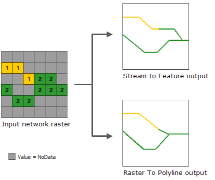
Comparing vectorizing stream network rasters methods

Reference

Tarboton, D. G., R. L. Bras, and I. Rodriguez-Iturbe. 1991. On the Extraction of Channel Networks from Digital Elevation Data. Hydrological Processes. 5: 81–100.

Related Topics

  • Stream to Feature
Feedback on this topic?

ArcGIS for Desktop

  • Home
  • Documentation
  • Pricing
  • Support

ArcGIS Platform

  • ArcGIS Online
  • ArcGIS for Desktop
  • ArcGIS for Server
  • ArcGIS for Developers
  • ArcGIS Solutions
  • ArcGIS Marketplace

About Esri

  • About Us
  • Careers
  • Insiders Blog
  • User Conference
  • Developer Summit
Esri
© Copyright 2016 Environmental Systems Research Institute, Inc. | Privacy | Legal