ArcGIS for Desktop

  • Documentation
  • Pricing
  • Support

  • My Profile
  • Help
  • Sign Out
ArcGIS for Desktop

ArcGIS Online

The mapping platform for your organization

ArcGIS for Desktop

A complete professional GIS

ArcGIS for Server

GIS in your enterprise

ArcGIS for Developers

Tools to build location-aware apps

ArcGIS Solutions

Free template maps and apps for your industry

ArcGIS Marketplace

Get apps and data for your organization

  • Documentation
  • Pricing
  • Support
Esri
  • Sign In
user
  • My Profile
  • Sign Out

Help

  • Home
  • Get Started
  • Map
  • Analyze
  • Manage Data
  • Tools
  • More...

Reclass by individual values

Available with Spatial Analyst license.

Reclassification tools change the values in a raster. The reclass by individual value tool changes one value to another in a one-to-one change. For example, while performing a deer habitat analysis, the values on a land use raster, each representing a different type of land use, need to be changed to a preference range—for example, 1 to 10—to make each land use type meaningful to deer. The types of land most preferred by deer are reclassed to higher values and those less preferred to lower values. For instance, the forest land use is reclassed to 10, the low-density residential land use to 5, and the industrial to 1.

The following example reclassifies the original values from the input base raster one at a time to new reclassified values. The output range of values is from 0 to 20.
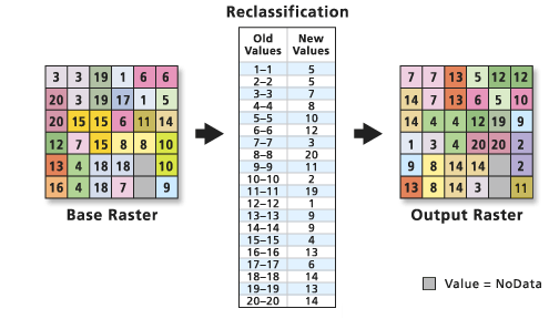
Example of reclassification by single values

Reclassifying individual values is usually done when the input values are categorical—for example, land use—or when changing only a few values.

Individual values can easily be reclassified through the Reclassify tool. The tool dialog box also allows for manual classification methods for the classification of the original data.

Related Topics

  • An overview of the Reclass tools
  • Using reclassification tables
Feedback on this topic?

ArcGIS for Desktop

  • Home
  • Documentation
  • Pricing
  • Support

ArcGIS Platform

  • ArcGIS Online
  • ArcGIS for Desktop
  • ArcGIS for Server
  • ArcGIS for Developers
  • ArcGIS Solutions
  • ArcGIS Marketplace

About Esri

  • About Us
  • Careers
  • Insiders Blog
  • User Conference
  • Developer Summit
Esri
© Copyright 2016 Environmental Systems Research Institute, Inc. | Privacy | Legal