Available with Standard or Advanced license.
When new parcels are added to the parcel fabric, they need to be joined to the parcel fabric to become part of the parcel fabric layer. A new parcel is not yet connected to the parcel fabric layer, even if existing fabric points were used as from- or to-points in the creation of the parcel. New parcels need to be joined to the parcel fabric to be connected to the parcel fabric. Since parcels can be created as floating geometries or floating features, this allows the data entry of parcels without the knowledge of coordinates, points of beginning, or spatial references. All that is required to enter a parcel in the parcel fabric are the recorded dimensions from the plan or record of survey.
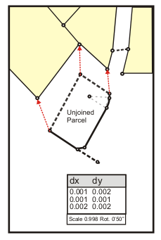
Parcel joining is an interactive process where the parcel points of a floating parcel or group of parcels are matched with their corresponding points in the parcel fabric.
Parcels can be joined to the parcel fabric using the following methods:
- Click Keep And Join
 on the Parcel Details dialog box after entering a new parcel.
 - Right-click an unjoined parcel in the Parcel Explorer window and click Join.
- Right-click a parcel in the parcel fabric layer and click Rejoin. You would rejoin a parcel to correct incorrect join links.
- Click Parcel Editor > Append File to append and join parcels stored in a cadastral xml file.
There are two join methods to choose from on the Join Parcel dialog box when joining parcels to the fabric layer:
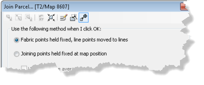
- Fabric points held fixed, line points moved to lines
Using this method, parcels being joined are fitted cartographically and topologically to the surrounding fabric.
- Joining points held fixed at map position
Using this method, the coordinate location of the floating parcels is held fixed and the surrounding fabric is fitted cartographically and topologically to the parcels being joined.
Fabric points held fixed
Using the Fabric points held fixed method, join parcels are fitted into the surrounding parcel fabric based on the established join lines. The join parcels are cartographically fitted to the surrounding fabric such that there are no slivers, gaps, or overlaps. This method is typically used when the surrounding fabric is considered equally or more accurate than the parcels being joined.
When using the Fabric points held fixed method, the following join tools are available:
- The Reset X And Y tool
 resets joining parcels to their original map location if you have dragged or moved the parcels during joining.
 - The Bring Joining Parcel To Map Extent tool
 places join parcels in the visible map extent.
Accuracy
Because join parcels are fitted cartographically to the surrounding fabric, the join parcels may be distorted to fit the surrounding fabric depending on the data quality. When joining more accurate parcels to less accurate surrounding parcels using the Fabric points held fixed method, it is important to specify the appropriate accuracy levels on the joining parcels and the surrounding parcels. If the joining parcel's accuracy is set to a higher level than the accuracy level of the surrounding parcels, a parcel fabric adjustment will result in the surrounding parcels adjusting around the more accurate parcel and the more accurate parcel maintaining its data integrity. Parcels with a higher accuracy level have a higher weight in a fabric least-squares adjustment and will adjust less than those parcels with a lower accuracy level and lower weight.
Line points
Join parcel points that are joined as line points to existing lines are automatically moved to the existing parcel lines.
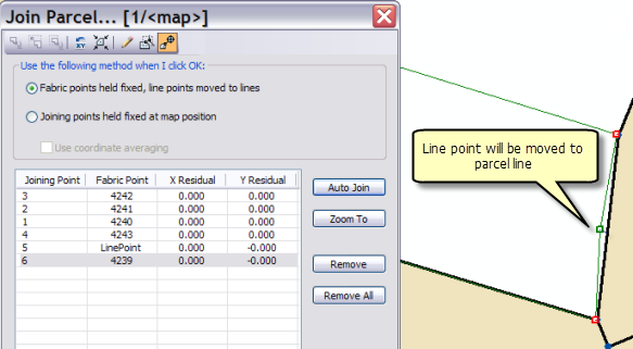
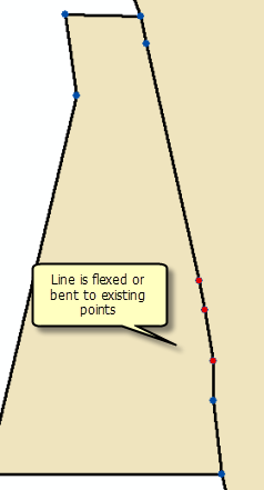
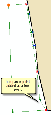
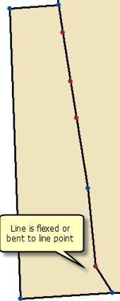
If a straight parcel line is joined to a series of existing lines that are not collinear, the straight line will be bent or flexed to the position of the existing parcel points as long as the existing parcel points have been added as line points. Straight lines are bent or flexed to their line points if they lie closer to their line points than the tolerance specified for Line-point under the Edit Environment tab of the Parcel Fabric Properties dialog box.
Joining points held fixed
Using the Joining points held fixed method, join parcels are held at a fixed position and the surrounding parcel fabric is fitted to the join parcels. This method allows you to preserve the shape of accurate parcels when joining them to less accurate surrounding parcels.
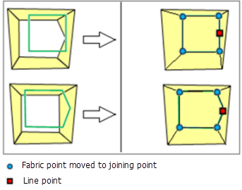
The Joining points held fixed method is not available if Limited cartographic points has been chosen under the Edit Environment tab on the Parcel Fabric Properties dialog box. Choosing Limited cartographic points assumes that the fabric is survey accurate and is only adjusted by a parcel fabric adjustment.
The Joining points held fixed method is also useful for appending parcel data with coordinates from parcel fabric XML files. The point coordinates in the parcel fabric XML file are used to place the parcels in the map extent. If parcels are appended from a different coordinate system or spatial reference, the parcels may not be visible in the map extent when first placed in the map. The Bring Joining Parcel To Map Extent tool  located on the Join Parcel dialog box can be clicked to place the parcels in the visible map extent.
The following tools on the Join Parcel dialog box are also available when using the Joining points held fixed method:
- The Reset X And Y tool
 can be used to reset joining parcels to their original coordinates if you have dragged or moved the parcels during joining.
 - Check the Use coordinate averaging check box to calculate an average (mean) between the join parcel coordinates and corresponding fabric coordinates when the fabric is fitted to the join parcels.
Scale and rotation
The Scale And Rotate tool  can be used to scale and rotate the joining parcel. Using this tool, rotation and scale values can be typed into the Join Parcel dialog box.
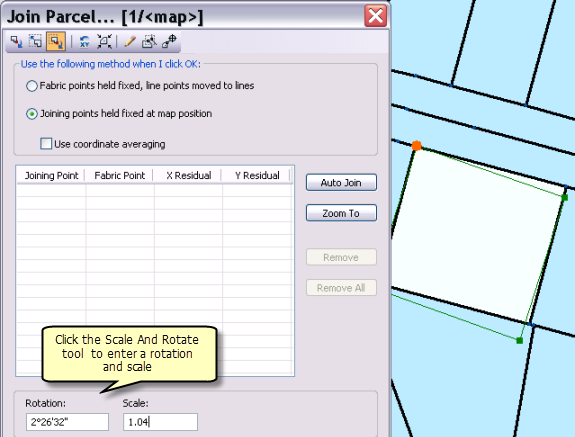
You can also scale and rotate joining parcels using the mouse. The scale and rotation values on the Join Parcel dialog box update as you scale and rotate the parcels.
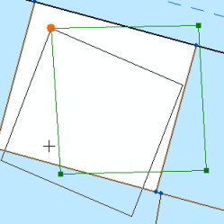
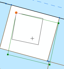
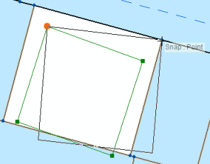
When using the mouse to scale and rotate joining parcels, you can snap joining parcel vertices to existing points and lines on the map.
Line points
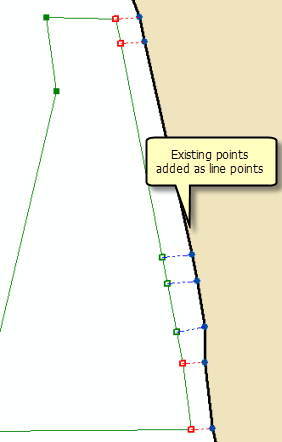
Existing fabric points that are joined as line points are automatically moved to the lines of the join parcel. If points on the joining parcel are added as line points to existing straight lines, these straight lines will be bent or flexed to the position of the line points such that there are no slivers, gaps, or overlaps. Straight lines are bent or flexed to their line points if they lie closer to their line points than the tolerance specified for Line-point under the Edit Environment tab of the Parcel Fabric Properties dialog box.
Join links
Join links are established between the join parcel's points and the corresponding points in the parcel fabric. Failure to establish a join link between a join parcel point and its matching fabric point will result in duplicate points for the same location. Overlapping points can result in gaps and slivers in the parcel fabric.
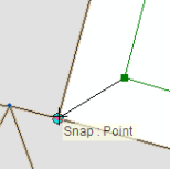
Join links can be manually created or created by dragging a box around the two points you want to join. To manually create a join link, the Join A Parcel Or Group Of Parcels tool  is used to snap to the joining parcel's point and to the corresponding point in the fabric.
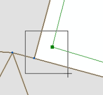
Join links can also be automatically created by dragging a box around the two points you want to join. The Create Join Link tool  is used to drag a box around the points to be joined.
Establishing join links using the trace link tool
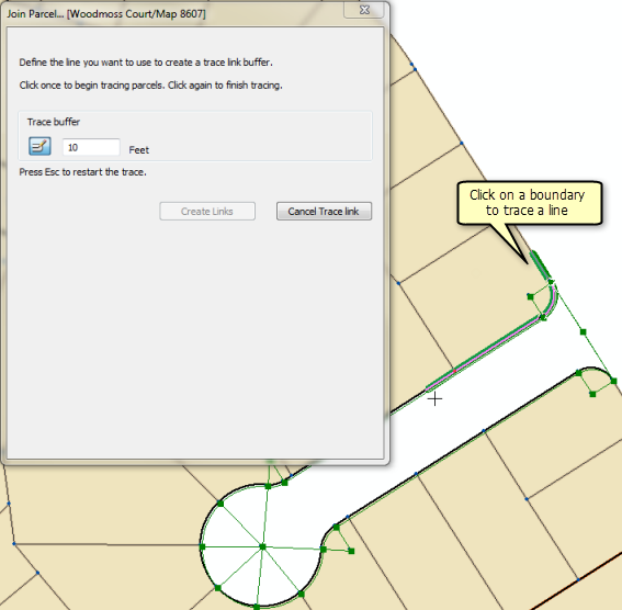
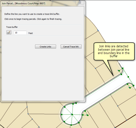
Instead of establishing join links individually point by point, you can use the Trace Fabric To Create Join Links tool  located on the Join Parcel dialog box to detect join links along traced boundaries. The trace link tool will detect join links between the joining parcel line and the traced boundary line if the joining parcel line lies within the specified trace link buffer.
To use the trace link tool, click the Trace Fabric To Create Join Links tool  on the Join Parcel dialog box, specify a trace buffer, and click a parcel boundary to begin tracing a line. Click a parcel boundary to finish tracing the line and click Create Links. Once the links are established, click Auto Join to detect any missing join links or line point links, and then click OK to join the parcel.
Make sure to set an appropriate join tolerance for detecting line points under Auto-join settings on the Tolerances tab on the Parcel Editor Options dialog box.
Autojoining
After at least two join links have been established, click Auto Join on the Join Parcel dialog box to detect any remaining or missing links.
Auto Join uses the transformation parameters from the existing established join links and applies them to all other points in the parcel group to detect other possible join lines. If there is a large difference in accuracy between the parcels being joined and the surrounding fabric, you may need to establish a few more join lines for Auto Join to correctly detect remaining join links.
Autojoin also detects line point join links. A line point join link occurs when a parcel point is joined to a parcel line.
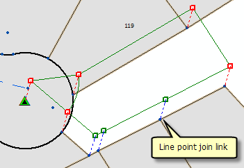
The autojoin process uses the Auto-join settings tolerance located on the Tolerances tab on the Parcel Editor Options dialog box. You can edit this tolerance to suit the quality of your data. For example, a small tolerance of about 0.3 feet can be used if the quality of both the joining parcel and surrounding parcels is good. If the joining parcel is more accurate than the surrounding fabric parcels, a small tolerance will not likely detect all line point links.
Join residuals
As each parcel point is matched with its corresponding fabric point, a set of join residuals, a scale, and a rotation are recomputed and displayed on the Join Parcel dialog box.
Join residuals are computed from a transformation between the joining parcel's points and the corresponding points in the parcel fabric. If only two points are joined, a Helmert transformation is used. If more than two points are joined, a least-squares transformation is used. Each time another point is joined, join residuals, scale, and rotation are recalculated.
Join residuals are only reported when using the Fabric points held fixed join method. Join residuals are an indication of how well the unjoined parcel fits with the surrounding parcel fabric. Large join residuals may result from a situation where the parcel being joined is more accurate than the surrounding parcel fabric. Large residuals may occur when the surrounding parcel fabric has been migrated from digitized data and the parcel being joined has been entered from the survey record. Large join residuals could also indicate an error in the dimensions of the parcel being joined.