Available with 3D Analyst license.
The interactive LAS dataset tools are a collection of tools for working with LAS datasets. A LAS dataset is a referenced container to a collection of LAS files containing lidar data. The LAS Dataset toolbar is available in ArcMap and in ArcScene. The LAS dataset toolbar provides an efficient way in which to toggle between different displays of the lidar points as a TIN-based surface or as a point cloud. The toolbar allows you to utilize the lidar point attributes, as well as display lidar data quickly by predefined filter settings.
It also offers a profile tool and editing capabilities via the 2D LAS Dataset Profile View. A LAS dataset can also be visualized in 3D in ArcMap with the LAS Dataset 3D View or in ArcScene as a LAS dataset layer. For more information on displaying LAS datasets, see An overview of displaying LAS datasets in ArcGIS.
To utilize any of the interactive 3D tools on the LAS Dataset toolbar, you require the ArcGIS 3D Analyst extension license.
For more information on editing capabilities for LAS datasets, see An overview of editing LAS datasets.
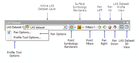
LAS dataset toolbar in ArcMap

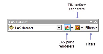
LAS dataset toolbar in ArcScene

LAS Dataset toolbar tools
The following table provides an initial description for the LAS dataset toolbar interactive tools. Select any of the tools to see more information on functionality.
| Toolbar tool | Description |
|---|---|
Control the offsets that the pan tools will move when selected from the LAS dataset toolbar. | |
Control the maximum number of points used in the 2D LAS Dataset Profile View window. | |
Select from a list of lidar-based point symbology renderers. | |
Select from a list of TIN-based surface symbology renderers. | |
Select from a list of predefined filters to display the LAS dataset as points or a surface. | |
Tools used to move throughout the LAS dataset in a specified distance. | |
Create a profile of LAS dataset points. Click a location in the map display to set a start point and a second location to set an end point. Once an end point has been set, use the selection box to set a profile width. Use the SHIFT key to set straight vertical or horizontal lines. Press the ESC key to cancel. The LAS dataset profile window allows you to view and edit the classification of the lidar points of the LAS dataset. | |
Navigate the LAS dataset using a 3D window. |