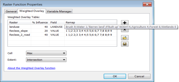
This function allows you to overlay several rasters using a common measurement scale and weight each according to its importance.

There are three parameters for this function: a table that defines the weights of the rasters, how the cell size is handled, and how the extent is handled.
Weighted Overlay Table
The simplest way to enter a weighted overlay table is to load a preexisting table. A weighted overlay table can be created using the Weighted Overlay geoprocessing tool. To create the table, open the tool, fill in the parameters, and click the Save Table button 
- Raster—All input rasters must be integer.
- % Influence—Each input raster is weighted according to its importance, or its influence, as a relative percentage. The sum of the percent influence weights must equal 100, and each weight must be specified by integer values.
- Field—An integer or string field on the input raster to use for weighting.
- Remap—Each value in an input raster is assigned a new value based
on the remap.
The remap value can be a valid value or a NoData value. The format of the string used to assign the remap is to specify the old value, a space, the new value followed by a semi colon.
The following table shows both original values and remap values. The remap string representing the information in the table is formatted 1 10;2 9;3 8
A table with original values and remap values.Original value Remap value 1
10
2
9
3
8
Cell Size
Choose the cell size to use for the output raster. If all the input cell sizes are the same, all the options will yield the same results.
| Cell size | Description |
|---|---|
First | Use the first cell size of the input rasters. This is the default. |
Last | Use the last cell size of the input rasters. |
Max | Use the largest cell size of all the input rasters. |
Mean | Use the mean cell size of all the input rasters. |
Min | Use the smallest cell size of all the input rasters. |
Extent
Choose which extent should be used for the output raster.
| Extent | Description |
|---|---|
First | Use the extent of the first input raster to determine the processing extent. This is the default. |
Intersection | Use the extent of the overlapping pixels to determine the processing extent. |
Last | Use the extent of the last input raster to determine the processing extent. |
Union | Use the extent of all the rasters to determine the processing extent. |