Available with 3D Analyst license.
Groups are used to define multiple levels of detail for line and polygon features. Since terrains do not have an automated way of generalizing lines and polygons, you need to do this up front and tell a terrain, through group definition, how the features should be used.
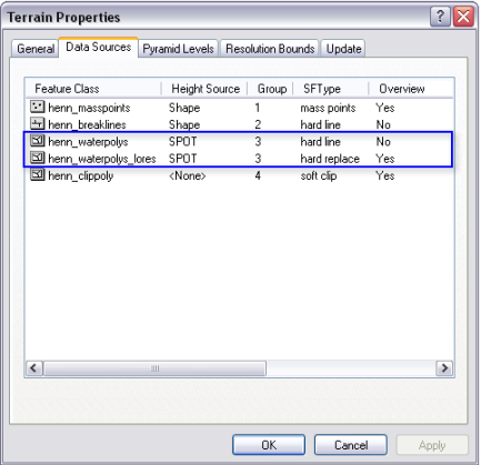
For example, you may have a very detailed clip polygon feature class that should be used only at large scales. You can create one or two generalized versions of this, via the Simplify Polygons tool, for use at smaller scales and define a group. Assigning the same group ID to each polygon feature class tells the terrain they belong to the same theme (for example, the study area boundary). You would then assign different resolution bounds to each as a means to describe in which pyramid levels each will be used. Since they represent the same thing at different levels of detail, they need to be enforced in different, non-overlapping pyramid levels. All a terrain really does when encountering multiple feature classes with the same group ID is make sure they participate in different pyramid levels. The example below shows two water polygons with the same group ID, which are to be enforced in different, non-overlapping pyramid levels.
There is no grouping for points or multipoints since a terrain dataset has a methodology for generalizing them.
In the New Terrain wizard, a line or polyline feature class can be set to a group in the Select Feature Class characteristics area on the New Terrain dialog box.
