The ST_Geometry data type implements the SQL 3 specification of user-defined data types (UDTs), allowing you to create columns capable of storing spatial data such as the location of a landmark, a street, or a parcel of land. It provides International Organization for Standards (ISO) and Open Geospatial Consortium, Inc. (OGC) compliant structured query language (SQL) access to the geodatabase and database. This storage extends the capabilities of the database by providing storage for objects (points, lines, and polygons) that represent geographic features. It was designed to make efficient use of database resources; to be compatible with database features such as replication and partitioning; and to provide rapid access to spatial data.
ST_Geometry itself is an abstract, noninstantiated superclass. However, its subclasses can be instantiated. An instantiated data type is one that can be defined as a table column and have values of its type inserted into it.
Although you can define a column as type ST_Geometry, you do not insert ST_Geometry values into the column since it cannot be instantiated. Instead, you insert the subclass values.
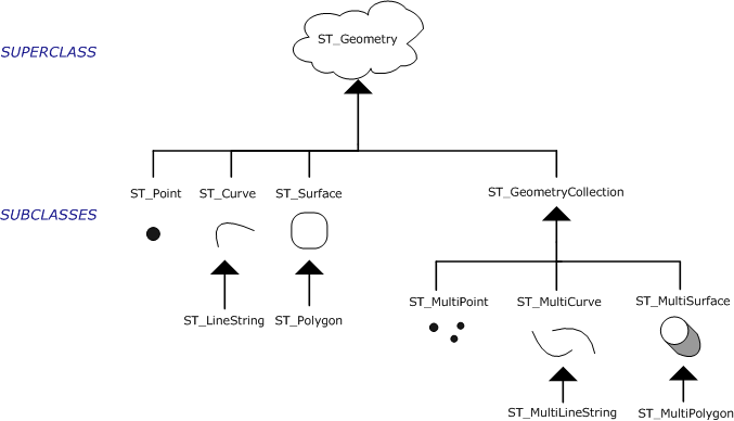
The following chart demonstrates the hierarchy of the ST_Geometry data type and its subclasses.

Subclasses
ST_Geometry's subclasses are divided into two categories: the base geometry subclasses and the homogeneous collection subclasses. The base geometries include ST_Point, ST_LineString, and ST_Polygon, while the homogeneous collections include ST_MultiPoint, ST_MultiLineString, and ST_MultiPolygon. As the names imply, the homogeneous collections are collections of base geometries. In addition to sharing base geometry properties, homogeneous collections have some of their own properties.
Each subclass stores the type of geometry implied by its name; for instance, ST_MultiPoint stores multipoints. A list of the subclasses and their descriptions are in the following table:
| Subtype | Description |
|---|---|
ST_Point |
|
ST_LineString |
|
ST_Polygon |
|
ST_MultiPoint |
|
ST_MultiLineString |
|
ST_MultiPolygon |
|
Note that each subclass inherits the properties of the ST_Geometry superclass but also has properties of its own. Functions that operate on the ST_Geometry data type accept any of the subclass entity types. However, some functions have been defined at the subclass level and only accept certain subclasses. For example, the ST_GeometryN function only takes ST_MultiLinestring, ST_MultiPoint, or ST_MultiPolygon subtype values as input.
To discover the subclass of an ST_Geometry, you can use the ST_GeometryType function. The ST_GeometryType function takes an ST_Geometry and returns the instantiated subclass in the form of a character string. To find out how many base geometry elements are contained in a homogeneous collection, you can use the ST_NumGeometries function, which takes a homogeneous collection and returns the number of base geometry elements it contains.