Summary
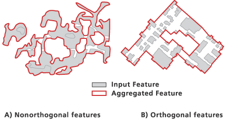
Combines disjoint and adjacent polygons into new area features based on a distance.
Illustration

Usage
The Input Coverage must have a polygon topology.
Due to the possibility of creating overlapping boundaries, preliminary regions are used as the resulting features. To create fully built regions from the preliminary regions, use the Clean tool with the POLY option on the Output Coverage.
The output coverage will not contain any attributes from the input coverage but will have a one-to-many relationship table, output_coverage.RXP (an INFO file), that links the aggregated preliminary regions to their source polygons. The .RXP extension stands for regions (output) cross-referencing polygons (input). This table will contain two items: output_coverage# and input_coverage#. With this link, you can derive attributes for the output features. The link can become incorrect when using the Clean tool to obtain region topology with a large fuzzy tolerance that causes small regions to collapse and disappear; the output_coverage# numbers will be reordered and not match the .RXP table.
Syntax
AggregatePolygons_arc (in_cover, out_cover, cell_size, distance, {orthogonal_option})| Parameter | Explanation | Data Type |
in_cover | The coverage containing polygons to be aggregated. | Coverage |
out_cover | The output coverage containing aggregated features as preliminary regions with a subclass AREAAGG. The output coverage name must be different from the input coverage name. | Coverage |
cell_size | Sets cell size in coverage units for grid conversion. Cell size must be greater than 0. | Double |
distance | Sets the aggregation distance in coverage units. A distance must be equal to or greater than the cell size. | Double |
orthogonal_option (Optional) | Specifies the characteristic of the input features that will be preserved when constructing the aggregated boundaries.
| Boolean |
Code sample
AggregatePolygons example (stand-alone script)
The following stand-alone script demonstrates how to use the AggregatePolygons tool.
# Name: AggregatePolygons_Example.py
# Description: Aggregates city limits polygons into a county boundary
# Requirements: ArcInfo Workstation

# Import system modules
import arcpy
from arcpy import env

# Set environment settings
env.workspace = "C:/data"

# Set local variables
inCover = "citylim"
outCover = "c:/output/countybnd"
cellSize = 10
distance = 150
orthogonalOption = "NON_ORTHOGONAL"

# Execute AggregatePolygons
arcpy.AggregatePolygons_arc(inCover, outCover, cellSize, distance,
                            orthogonalOption)
Environments
Licensing information
- ArcGIS Desktop Basic: No
- ArcGIS Desktop Standard: No
- ArcGIS Desktop Advanced: Requires ArcInfo Workstation installed