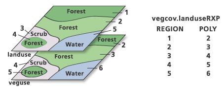
The Polygon Coverage to Region tool makes regions from polygons. It is one method of creating a region coverage.
Polygon Coverage to Region creates a coverage with the specified region subclass. Each polygon in the input coverage (with the exception of the universe polygon) is copied as a region of the output subclass, creating a one-to-one relationship between nonuniverse polygons and regions.
Attributes from the PAT are copied to the region PAT.
If several polygons are to be combined into one region, use the Dissolve tool to join adjacent or nonadjacent regions with the same attributes. Dissolve can create new regions from polygons or regions by selecting them and dissolving with one or more specified attributes.
This figure shows an example of Polygon Coverage to Region. A region subclass landuse is created for the input polygon coverage vegcov. Each polygon is converted to a region, hence a one-to-one mapping of polygons and their attributes to a region subclass.
polyregion_arc vegcov vegcov landuse

vegcov.patlanduse
| Record | AREA | PERIMETER | LANDUSE# | lANDUSE-ID | ATTR1 | ATTR2 |
|---|---|---|---|---|---|---|
1 | 11.958 | 16.856 | 1 | 1 | Forest | 100 |
2 | 21.489 | 26.812 | 2 | 2 | Forest | 200 |
3 | 13.882 | 15.116 | 3 | 3 | Scrub | 100 |
4 | 1.541 | 5.182 | 4 | 5 | Forest | 200 |
5 | 1.517 | 5.161 | 5 | 4 | Water | 999 |