ArcGIS Desktop

  • Documentation
  • Support

  • My Profile
  • Help
  • Sign Out
ArcGIS Desktop

ArcGIS Online

The mapping platform for your organization

ArcGIS Desktop

A complete professional GIS

ArcGIS Enterprise

GIS in your enterprise

ArcGIS for Developers

Tools to build location-aware apps

ArcGIS Solutions

Free template maps and apps for your industry

ArcGIS Marketplace

Get apps and data for your organization

  • Documentation
  • Support
Esri
  • Sign In
user
  • My Profile
  • Sign Out

ArcMap

  • Home
  • Get Started
  • Map
  • Analyze
  • Manage Data
  • Tools
  • Extensions

How to set snapping tolerance in 3D

Available with 3D Analyst license.

The snapping tolerance is the distance within which the pointer or a feature is snapped to another location. If the element being snapped to, such as a vertex or edge, is within the distance you set, the pointer automatically snaps to the location.

You will know that snapping is going to occur because the pointer icon will change as you enter within the snapping tolerance. The images below illustrate the pointer change, highlighted in the blue square. When digitizing new features, as the crosshair pointer approaches the next available snapping location—such as a vertex—it changes to a clear arrow. This example shows the line will jump ahead and attach to the vertex. You still have to click to have the snap completed.
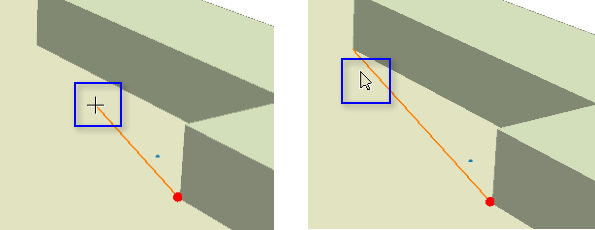
In the 3D editing environment, the pointer will change shape to a clear arrow when you are about to snap to another element.

  1. Click the 3D Editor menu.
  2. Click Snapping and click Options.
  3. Choose the type of measurement unit you want to use for snapping tolerance—pixels or map units.
  4. Pixels is the same as fixed screen size, whereas map units is equivalent to real-world units.
  5. Type the desired number of measurement units in the Snapping tolerance text box.
  6. The smaller the value, the closer your pointer needs to be to the element for snapping to occur.
  7. Click OK.

ArcGIS Desktop

  • Home
  • Documentation
  • Support

ArcGIS Platform

  • ArcGIS Online
  • ArcGIS Desktop
  • ArcGIS Enterprise
  • ArcGIS for Developers
  • ArcGIS Solutions
  • ArcGIS Marketplace

About Esri

  • About Us
  • Careers
  • Insiders Blog
  • User Conference
  • Developer Summit
Esri
Tell us what you think.
Copyright © 2018 Esri. | Privacy | Legal