Available with 3D Analyst license.
About configuring the ArcGlobe startup display
When you start ArcGlobe for the first time, you will notice there are already some layers in the table of contents; these automatic layers are services from ArcGIS Online. You can alternatively configure ArcGlobe to use a different set of default layers, such as other Esri-provided basemap layers; use your own set of layers; or have no default layers at all. The purpose of default layers is to provide a background or starting point from which you can begin using ArcGlobe.
You can also customize how you want the globe to appear when no layers are being displayed as draped on the surface of the globe. You can have a wire mesh or an empty globe, with only the default background effects, such as the atmospheric halo, as an outline.
The ArcGlobe default layers
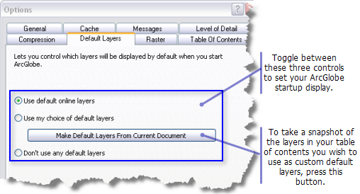
Defining your own set of layers to use as the ArcGlobe default content can be done at any time by taking a snapshot of the current document. These user-defined default layers are maintained by the system as what you chose to be in the table of contents. This way, if at any time you want to change the default layers, you can toggle between other choices or return to the option of loading your layers by default without having to specify them again.
If you are used to using the system-supplied, coarse layers that come with ArcGlobe, that choice will only continue to be honored should you open an older document that was saved using that option. Once you click another option, at that point, it will no longer be available on the interface because it is deprecated with ArcGIS 10. The system-supplied layers are always available in your local directory where ArcGIS is installed and can be used as a custom choice of default layers.
To explore additional 3D basemaps and other data hosted online by Esri, utilize the ArcGIS.com website. These services are available on the web to use at any time and are updated frequently. A Search capability is provided so you can find or browse data and maps you want to use.
Learn more about adding an ArcGIS Online basemap into ArcGlobe
Learn more about adding data from ArcGIS Online
This image highlights the options that are available to set as your ArcGlobe default layers:

The globe surface without layers
The Customize > ArcGlobe Options > Default layers tab also allows you to define the view of the globe when no draped layers are being displayed on the surface.
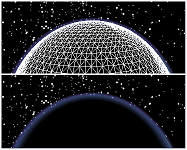
Check the Show the elevation mesh option if you want to display a wire mesh when no other draped layers are visible. If unchecked, the globe surface will remain empty and still honor any default background effects such as the atmospheric halo.
The image below illustrates the wire mesh in the top example and the empty globe surface, if the option is unchecked, in the bottom example:
