ArcGIS Desktop

  • Documentation
  • Support

  • My Profile
  • Help
  • Sign Out
ArcGIS Desktop

ArcGIS Online

The mapping platform for your organization

ArcGIS Desktop

A complete professional GIS

ArcGIS Enterprise

GIS in your enterprise

ArcGIS for Developers

Tools to build location-aware apps

ArcGIS Solutions

Free template maps and apps for your industry

ArcGIS Marketplace

Get apps and data for your organization

  • Documentation
  • Support
Esri
  • Sign In
user
  • My Profile
  • Sign Out

ArcMap

  • Home
  • Get Started
  • Map
  • Analyze
  • Manage Data
  • Tools
  • Extensions

Create a mosaic dataset using the Multiband Composite template

    This workflow describes the steps to create a mosaic dataset using the Multiband Composite template.

    1. Create a mosaic dataset using the Create Mosaic Dataset geoprocessing tool.
    2. Add data using the Add Rasters To Mosaic Dataset geoprocessing tool.
      1. Choose one of the multidimensional raster types: GRIB, HDF, or NetCDF.
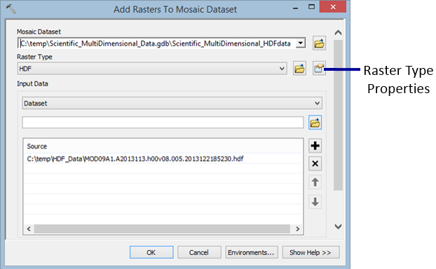
        Raster Type Properties button

      2. Specify the input file or workspace containing the files.

        If your input is only one or two files, choose the File option rather than the Workspace option, as it performs faster.

      3. Click the Raster Type Properties button.

        The Raster Type Properties dialog box appears.

      4. Click the General tab and choose the Multiband Composite processing template.
      5. Click the Variables tab and choose the variables you want to include in your mosaic dataset composite.
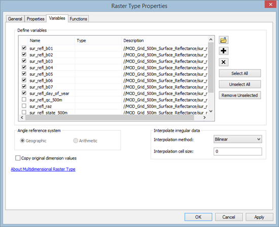
        Selected variables to include in the Multiband Composite
      6. Click OK to close the Raster Type Properties dialog box.
      7. Check Estimate Mosaic Dataset Statistics in the Mosaic Post-processing section.
      8. Click OK to run the tool.

        The output result is automatically added to the map.

      The band information is listed under the Key Metadata tab in the Raster Function Properties window of the item listed in the attribute table of the mosaic dataset.
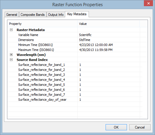
      Multidimensional mosaic dataset Raster Function Properties

    Related topics

    • Drawing raster data using vector symbols
    • Multidimensional data in a mosaic dataset
    • Multidimensional raster types

    ArcGIS Desktop

    • Home
    • Documentation
    • Support

    ArcGIS Platform

    • ArcGIS Online
    • ArcGIS Desktop
    • ArcGIS Enterprise
    • ArcGIS for Developers
    • ArcGIS Solutions
    • ArcGIS Marketplace

    About Esri

    • About Us
    • Careers
    • Insiders Blog
    • User Conference
    • Developer Summit
    Esri
    Tell us what you think.
    Copyright © 2017 Esri. | Privacy | Legal