ArcGIS Desktop

  • ArcGIS Pro
  • ArcMap

  • My Profile
  • Help
  • Sign Out
ArcGIS Desktop

ArcGIS Online

The mapping platform for your organization

ArcGIS Desktop

A complete professional GIS

ArcGIS Enterprise

GIS in your enterprise

ArcGIS for Developers

Tools to build location-aware apps

ArcGIS Solutions

Free template maps and apps for your industry

ArcGIS Marketplace

Get apps and data for your organization

  • Documentation
  • Support
Esri
  • Sign In
user
  • My Profile
  • Sign Out

ArcMap

  • Home
  • Get Started
  • Map
  • Analyze
  • Manage Data
  • Tools
  • Extensions

Specifying a minimum feature size for labeling

Another way to control label density in an area is to reduce the number of small features that are being labeled. If your layer contains many small insignificant features that do not require a label, you can use the Maplex Label Engine to remove the features from the list of features to be labeled.

The Minimum feature size for labeling property is only available for line and polygon features. For line labeling, the value is specified as the length of the line in the current map units or in page units (millimeters, inches, or points). For polygon labeling, the value is specified as the length of the polygon perimeter or the area in map units or in page units (millimeters, inches, or points).

In the image below, the minimum feature size was set to 300 square kilometers.
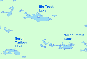
Minimum feature size of 300 sq km
  1. Enable the Maplex Label Engine.
  2. Click the Label Manager button Label Manager on the Labeling toolbar.
  3. Choose the label class for the layer you want to modify.
  4. Click the Properties button.
  5. Click the Label Density tab.
  6. Enter a Minimum feature size for labeling value.
  7. This distance is measured in map units or in page units (millimeters, inches, or points).

  8. Click OK to close all dialog boxes.
Tip:
You can also open the Placement Properties dialog box by clicking the Placement Properties button on the Labels tab on the Layer Properties dialog box for the layer you want to label.

ArcGIS Desktop

  • Home
  • Documentation
  • Support

ArcGIS Platform

  • ArcGIS Online
  • ArcGIS Desktop
  • ArcGIS Enterprise
  • ArcGIS for Developers
  • ArcGIS Solutions
  • ArcGIS Marketplace

About Esri

  • About Us
  • Careers
  • Esri Blog
  • User Conference
  • Developer Summit
Esri
Tell us what you think.
Copyright © 2020 Esri. | Privacy | Legal