Summary
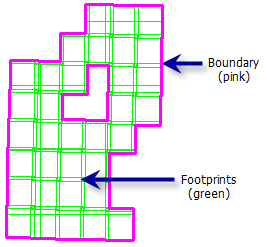
Updates the extent of the boundary when adding new raster datasets to a mosaic dataset that extend beyond its previous coverage.
Illustration

Usage
Boundaries can only be generated for mosaic datasets stored within a geodatabase.
If you remove or add rasters, or modify the extent of the footprints, you should use this tool to rebuild the boundary.
If you modify the shape of the boundary polygon (using editing tools), you can use this tool to recreate the original (unmodified) boundary.
Syntax
BuildBoundary_management (in_mosaic_dataset, {where_clause}, {append_to_existing}, {simplification_method})| Parameter | Explanation | Data Type |
in_mosaic_dataset | Select the mosaic dataset where you want to recompute the boundary. | Mosaic Layer |
where_clause (Optional) | An SQL Query to compute a boundary for select raster datasets. Use this option in conjunction with setting the append_to_existing parameter to APPEND to save time when adding new raster datasets. | SQL Expression |
append_to_existing (Optional) | Set this to APPEND when adding new raster datasets to an existing mosaic dataset. Instead of calculating the entire boundary, APPEND will merge the boundary of the new raster datasets with the existing boundary.
| Boolean |
simplification_method (Optional) | The simplification method reduces the number of vertices, since a dense boundary can affect performance. Choose which simplification method to use to simplify the boundary.
| String |
Code sample
BuildBoundary example (Python window)
This is a Python sample for the BuildBoundary tool.
import arcpy
arcpy.BuildBoundary_management("c:/workspace/Boundary.gdb/md", "#",
                               "APPEND", "CONVEX_HULL")
Build Boundary example 2 (stand-alone window)
This is a Python script for the BuildBoundary tool.
# Build boundary only for the Quickbird data

import arcpy
arcpy.env.workspace = "C:/Workspace"

mdname = "boundary.gdb/md"
query = "SensorName = 'QuickBird'"
mode = "OVERWRITE"
simplify = "#"

arcpy.BuildBoundary_management(mdname, query, mode, simplify)
Environments
Licensing information
- ArcGIS Desktop Basic: No
- ArcGIS Desktop Standard: Yes
- ArcGIS Desktop Advanced: Yes