Summary
Standardizes the address information in a table or feature class.
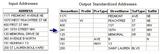
Addresses are often presented in different forms that may contain various abbreviations of words, such as "W" for "WEST" or "ST" for "STREET". Based on an address style you select, the address can be broken into multiple parts, such as House Number, Prefix Direction, Prefix Type, Street Name and Street Type. Each part will contain a piece of address information and the standardized value, such as "1ST" instead of "FIRST" as Street Name, "AVE" instead of "AVENUE" as Street Type. The address style specifies the components of an address and determines how the components are ordered and standardized. Depending on the applications, some address styles may expand the value of a word instead of abbreviating it.
The input address you want to standardize can be stored in a single field. If the address information has already been split into multiple fields in the input feature class or table, this tool can concatenate the fields on the fly and standardize the information.
Illustration

Usage
The input address data can be a table or feature class that contains address attributes that can be standardized based on an address locator style.
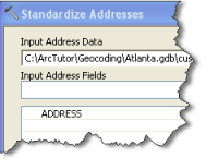
The input address you want to standardize can be stored in a single field, such as the Address field in a customer address table. You can then select the field as the Input Address Field in the tool.

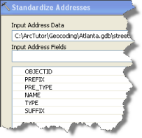
If the address information has already been broken into multiple fields in the input feature class or table which you can find in common reference street or point address data, the standardization process will concatenate the fields on the fly and standardize the information. You specify the fields in the order that forms the complete address.

The standardized result can be saved in one of the following two output options:
- An output table or feature class that contains a copy of the rows or features in the input table and the standardized address fields. This is the default option.
- An output table that contains only the standardized address fields and a relationship class that joins to the input table or feature class.
Syntax
StandardizeAddresses_geocoding (in_address_data, in_input_address_fields, in_address_locator_style, in_output_address_fields, out_address_data, {in_relationship_type})| Parameter | Explanation | Data Type |
in_address_data | The table or feature class containing address information that you want to standardize. | Table View |
in_input_address_fields [in_input_address_field,...] | The set of fields in the input table or feature class that, when concatenated, forms the address to be standardized. | Field |
in_address_locator_style | The address locator style to use to standardize the address information in the input table or feature class. | Address Locator Style |
in_output_address_fields [in_output_address_field,...] | The set of standardized address fields to include in the output table or feature class. | Field |
out_address_data | The output table or feature class to create containing the standardized address fields. | Table;Feature Class |
in_relationship_type (Optional) | Indicates whether to create a static or dynamic output dataset.
| Boolean |
Code sample
StandardizeAddresses Example (Python Window)
The following Python window script demonstrates how to use the StandardizeAddresses function in immediate mode.
import arcpy
env.workspace = "C:/ArcTutor/geocoding/atlanta.gdb"

# Set local variables:
input_feature_class = "streets"
address_fields = "ID;FULL_STREET_NAME"
locator_style = "US Address-Dual Ranges"
standardized_fields = "PreDir;PreType;StreetName;SufType;SufDir"
standardized_feature_class = "StandardizedStreet"

arcpy.StandardizeAddresses_geocoding(input_feature_class, address_fields, locator_style, standardized_fields, standardized_feature_class, "Static")
Environments
Licensing information
- ArcGIS Desktop Basic: Yes
- ArcGIS Desktop Standard: Yes
- ArcGIS Desktop Advanced: Yes