The ArcMap editing environment provides several ways to maintain the attribute integrity of your data. For example, you can use topology to edit shared geometry to maintain coincident borders. In addition, ArcMap is tightly integrated with the various special aspects of the geodatabase, such as topology and geometric networks. Although each component of the geodatabase can act independently, the true power of the geodatabase becomes evident when you bring all these things together. You can use ArcMap editing capabilities to take advantage of the aspects of a geodatabase that help you maintain a valid database.
Editing shared geometry
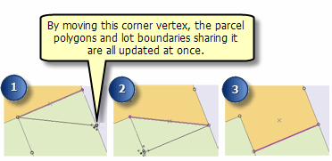
You might find that you need to edit the geometry of multiple features at once. Using the topological association among features, you can move boundaries and vertices shared by multiple features. For example, you can move a border to update two forest polygons or, as seen in the graphic below, move a corner vertex and update several parcel polygons and a few lot boundaries at the same time.

Within the editing environment, you can create a map topology that enables you to edit the shared parts of features. A map topology is a temporary set of topological relationships between coincident parts of simple features on a map. The primary types of geometry that are acted on when editing a map topology are edges, which are line segments that define lines or polygons, and nodes/points at the end of an edge. When you move a node in a topology, all the edges that connect to it are stretched to stay connected to the node. When you move an edge, edge segments stretch to maintain the connection of shared endpoint nodes to their previous location. You can also move a node and a connected edge without stretching the other connected edge by temporarily splitting the topological relationship between the node and the other shared edges.
When creating a map topology, you need to specify which layers will participate in the topology and a cluster tolerance that is used to determine which parts of the features are coincident and which edges and nodes in the topology are shared.
Maintaining spatial integrity in geodatabases
Beyond editing shared geometry, topology within a geodatabase allows you to maintain additional spatial integrity by specifying a set of rules to apply to your data, allowing you to find and fix any errors and validate relationships.
Geodatabase topology
Topology is a collection of rules that, coupled with a set of editing tools and techniques, enables the geodatabase to more accurately model geometric relationships. ArcGIS implements topology through a set of rules that define how features may share a geographic space and a set of editing tools that work with features that share geometry in an integrated fashion. A topology is stored in a geodatabase as one or more relationships that define how the features in one or more feature classes share geometry. The features participating in a topology are still simple feature classes—rather than modifying the definition of the feature class, a topology serves as a description of how the features can be spatially related.
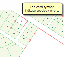
For example, in the graphic below, the coral-colored squares and lines indicate errors in topology, which is one way of ensuring spatial integrity. These may be locations where there is a line that does not connect to another line (known as a dangle), a polygon that does not contain a point within its boundary, or some other violation of a rule imposed on the geodatabase.

ArcGIS provides a set of editing tools that help find and fix topology rule violations. Violations of topology rules are initially marked as errors in the topology, but where appropriate, you can mark them as exceptions. Within the editing environment, you can use the tools on the Topology toolbar to locate errors, fix errors interactively or automatically, validate edits, and create new features from the geometry of existing features. Dirty areas track the places where topology rules may have been violated during editing. Depending on your workflow, you can validate topology rules and clean up dirty areas after each edit session or on a schedule.
Geometric networks
Geometric networks also store various mechanisms and behaviors that maintain the topological connectivity between their component features. Geometric networks consist of edge network features and junction network features. An example of an edge feature is a water main, and a junction feature might be a valve. Edges must be connected to other edges through junctions.
Geometric network connectivity rules constrain the type of network features that may be connected to one another and the number of features of any particular type that can be connected to features of another type. By establishing these rules along with other rules, such as attribute domains, you can maintain the integrity of the network data in the database. At any time, you can selectively validate features in the database and generate reports as to which features in the network are invalid—that is, are violating one of the connectivity or other rules.
Edit operations that involve adding, deleting, and moving geometric network features can all affect the connectivity of a geometric network. Connectivity between network features is maintained on the fly as you create, delete, and modify network features. For example, when a network edge or junction is moved, the network features to which it is connected respond by stretching and adjusting themselves to maintain connectivity. You can use the geometric network editing tools to modify, rebuild, and verify connectivity.