Summary
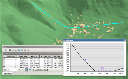
Creates a table and optional graph denoting the profile of line features over one or more multipatch, raster, TIN, or terrain surfaces.
Illustration

Usage
If the Output Graph Name parameter is populated and the tool is executed in ArcMap, ArcScene, or ArcGlobe, the resulting graph will be displayed on-screen.
The output table provides the information needed for generating the profile graph. Each line feature is densified along its overlapping profile targets in a manner that captures the profile's characteristics by introducing new vertices along the line. The elevation and distance along the input lines created by this densification gets stored in the output table along with the additional information about the line features and profile targets. The values in its fields can be used to create graphs in a wide variety of external applications. The fields represent:
- FIRST_DIST—Distance to the first vertex in the profile segment.
- FIRST_Z—Height of the first vertex in the profile segment.
- SEC_DIST—Distance of the second vertex in the profile segment.
- SEC_Z—Height of the second vertex in the profile segment.
- LINE_ID—Unique ID of the line feature used to define the profile.
- SRC_TYPE—Data type of the profile's source, which is either a surface or multipatch.
- SRC_ID—Unique ID of the multipatch feature being profiled. Not applicable for surface inputs.
- SRC_NAME—Name and path to the profile's source.
Syntax
StackProfile_3d (in_line_features, profile_targets, out_table, {out_graph})| Parameter | Explanation | Data Type |
in_line_features | The line features that will be profiled over the surface inputs. | Feature Layer |
profile_targets [profile_targets,...] | The data being profiled, which can be comprised from any combination of multipatch features, raster, and triangulated surface models. | Feature Layer; LAS Dataset Layer; Mosaic Layer; Raster Layer; Terrain Layer; TIN Layer |
out_table | The output table that will store the height interpolated for each profile target that intersects the input line. | Table |
out_graph (Optional) | The name of the output graph that can be viewed in ArcMap, ArcScene, or ArcGlobe. | Graph |
Code sample
StackProfile example 1 (Python window)
The following sample demonstrates the use of this tool in the Python window.
import arcpy
from arcpy import env

arcpy.CheckOutExtension('3D')
env.workspace = 'C:/data'
arcpy.StackProfile_3d('profile_line.shp', 'dem.tif; buildings.shp',
                     'profile_values.dbf', 'Surface Profile')
StackProfile example 2 (stand-alone script)
The following sample demonstrates the use of this tool in a stand-alone Python script.
'''**********************************************************************
Name: Save Profiles to Graph Files
Description: Creates profile graphs of multipatch and surface features,
             which are then saved as graph files.
**********************************************************************'''
# Import system modules
import arcpy
import exceptions, sys, traceback

# Set Local Variables
profileLine = arcpy.GetParameterAsText(0)
profileTargets = arcpy.GetParameterAsText(1) # input las files
profileTable = arcpy.CreateUniqueName('profile_table', 'in_memory')
graphName = "Sample Graph"
outGraph = arcpy.GetParameterAsText(2) # output graph file

try:
    arcpy.CheckOutExtension('3D')
    # Execute StackProfile
    arcpy.ddd.StackProfile(profileLine, profileTargets, profileTable, graphName)
    # Execute SaveGraph
    arcpy.management.SaveGraph(graphName, outGraph)
    arcpy.CheckInExtension('3D')
except arcpy.ExecuteError:
    print arcpy.GetMessages()
except:
    # Get the traceback object
    tb = sys.exc_info()[2]
    tbinfo = traceback.format_tb(tb)[0]
    # Concatenate error information into message string
    pymsg = 'PYTHON ERRORS:\nTraceback info:\n{0}\nError Info:\n{1}'\
          .format(tbinfo, str(sys.exc_info()[1]))
    msgs = 'ArcPy ERRORS:\n {0}\n'.format(arcpy.GetMessages(2))
    # Return python error messages for script tool or Python Window
    arcpy.AddError(pymsg)
    arcpy.AddError(msgs)
Environments
Licensing information
- ArcGIS Desktop Basic: Requires 3D Analyst
- ArcGIS Desktop Standard: Requires 3D Analyst
- ArcGIS Desktop Advanced: Requires 3D Analyst