To find information about the projection used to create a map, look at its legend. The legend of a map may list a projection by name and give its parameters, such as Lambert conformal conic with standard parallels at 34° 02' N and 35° 28' N and origin at 118° W, 33° 30' N. Or it may list a coordinate system and zone number, such as California Coordinate System zone 5 or State Plane Coordinate System zone 3376.
It is also important, especially for large-scale maps, to know the spheroid used. The U.S. standard was Clarke 1866 (for NAD27), but the standard now is GRS80 (for NAD83). The spheroid is sometimes inherent to a coordinate system, such as Clarke 1866 for older State Plane maps or GRS80 for newer ones.
The following is an example of a map's projection information for a USGS 7.5-minute topographic map:
- Mapped, edited, and published by the Geologic Survey Control by USGS and USC&GS Topography by plane table surveys 1942. Revised 1955 polyconic projection. 1927 North American Datum 10,000-foot grid based on Rhode Island coordinate system 1000-meter universal transverse Mercator grid tz
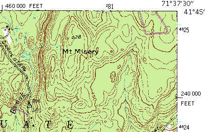
Along the margins of most maps, you will find one or more sets of coordinates that reference locations on the earth's surface. On a USGS 7.5-minute topographic series map, three types of coordinates are provided: the projection of the map, universal transverse Mercator meters, and latitude-longitude degrees. The example below displays three different systems of coordinate and projection information along the graticule of a USGS 7.5-minute quadrangle.

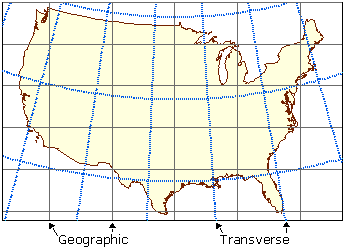
For small-scale maps that contain multiple coordinate systems, there is an additional consideration. As the following graphic shows, all map projections distort the earth in different ways; therefore, lines of equal coordinate value may have different curvatures.

For this reason, it is best to use graticular intersections on the map. In contrast to drawing straight lines across a map to connect coordinates on either side, graticule lines may be represented by curved lines. This is less of a concern for large-scale maps. It is not a problem for equatorial aspects of cylindrical projections, such as Mercator.