Available with Standard or Advanced license.
You can label and use geodatabase annotation on parcel fabric sublayers. Labels are automatically generated and are not editable or selectable. Labeling can be a fast way to add text to your parcel map where manual editing of the text is not necessary. If you need more flexibility with your labeling, you can use annotation to select, move, and edit text on your map. To work with annotation, labels are typically generated for the layer and then converted to annotation. You can store your annotation either in the map document or in a related geodatabase feature class.
If working with annotation, you can create feature-linked annotation. Feature-linked annotation is a type of geodatabase annotation that is directly linked to features. Feature-linked annotation moves and updates with the feature to which it is linked. For example, if the distance on a parcel line is updated, feature-linked annotation updates to show the new distance value.
Feature-linked annotation can be created for the following parcel fabric feature classes:
- Control points
- Lines
- Parcels
- Points
Feature-linked annotation links to parcel fabric feature classes through a composite relationship. The parcel fabric feature classes are the origin feature classes in the relationship. When editing parcels in the parcel fabric, any feature-linked annotation is updated when edits are made to the data referenced by the annotation. For example, if you change the dimension of a parcel boundary (bearing, distance), the feature-linked annotation updates to reflect the change once the parcel changes are saved.
Annotate Parcel Courses tool
The Annotate Parcel Courses tool  on the Parcel Editor toolbar can be used to annotate a selection of parcels using an existing or empty feature-linked annotation class. The
tool opens the Annotate Selected Features dialog box, which displays a list of available annotation classes that are feature-linked to parcel fabric tables.
The tool converts labels to annotation, creates new annotation, and overwrites any existing annotation. Duplicate annotation is removed.
Creating feature-linked annotation for parcel fabric sublayers
To create labels for a parcel fabric sublayer and then convert them to feature-linked annotation, follow these steps:
- In ArcMap, add the Labeling toolbar and open the Label Manager.
- On the Label Manager dialog box, turn on labeling for the parcel fabric sublayer to which you want to add text.
- Choose the attribute field you want to use to generate labels from the Label Field drop-down box.
- To label features differently—for example, to use different attribute fields to label different features in the same layer—you need to create new label classes for each set of labels. On the Label Manager dialog box, choose the layer to create a new label class.
- To customize the labels generated from the attribute field, use label expressions.
- Ensure that the label scale and properties have been appropriately set, as they determine the size, position, and appearance of the converted annotation.
- Right-click the parcel fabric sublayer that has the labels you want to convert and click Convert Labels to Annotation.
- On the Convert Labels to Annotation dialog box, choose whether to store the annotation in the geodatabase or in the map.
- Choose whether you want to create annotation for all features, features in the current map extent, or selected features.
- Make sure the Feature Linked check box is checked.
- Make sure Convert unplaced labels to unplaced annotation is checked so you don't lose labels that were unplaced.
- Click Convert to convert labels to annotation.
[Distance] & " ft"
The Hide field and labeling
The Hide field on the parcel lines table is used by the parcel fabric to detect duplicate dimensions when new parcels are created or when parcels are migrated to the fabric. The Hide field is automatically flagged to 1 (true) when dimensions are inversed and detected as duplicates for a common parcel boundary. For example, if data is migrated to the parcel fabric and dimensions are inversed for parcel lines, and if duplicate dimensions are detected for a common parcel boundary, the Hide field will be flagged to 1 (true) for one of the parcel lines. Another example is when parcels are built from construction lines. If duplicate dimensions are detected for a common parcel boundary, the Hide field will automatically be flagged to 1 (true) for one of the parcel lines.
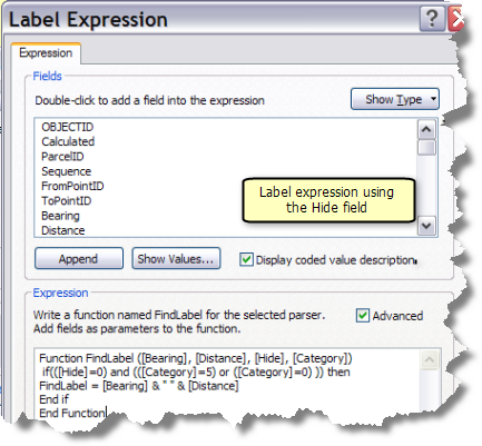
The Hide field can be used in a label expression to remove duplicate labels when labeling parcel features. For example, in the following label expression function, only those parcel lines with a Hide value of 0 (false) are labeled with a bearing and distance.
Label Expression
Function FindLabel ([Bearing], [Distance], [Hide], [Category])
 if(([Hide]=0) and (([Category]=5) or ([Category]=0) )) then
FindLabel = [Bearing] & " " & [Distance]
End if
End Function
