Features are often defined in relation to parcel boundaries. For example, road centerlines are offset from parcel boundaries, zoning districts follow parcel boundaries, and building footprints lie within parcel boundaries. Road centerlines, zoning polygons and building footprint polygons are all edited and created using parcel boundaries as a background reference.
About the parcel fabric feature adjustment
Feature classes that are related to parcel boundaries can be associated to the parcel fabric. Parcel fabric points shift in response to least-squares adjustments or other edits such as transformations, joining or regeneration. When parcel fabric points shift, vectors are generated between the old and new coordinates of the point and stored in the parcel fabric Vectors table. The parcel fabric feature adjustment uses the vector shifts in a rubber-sheeting process to realign features with adjusted parcel boundaries.
The adjusted date
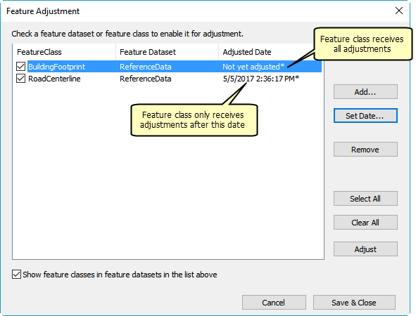
The set of vectors generated when parcel fabric points shift is date and time stamped. When a feature class is first associated with the parcel fabric, its adjusted date is set to Not yet adjusted. When the feature class first participates in a feature adjustment, it receives adjustments from all vectors that coincide with its features. Its adjusted date is changed to correspond with the date and time of the most recent set of vectors.
For example, a set of parcels is adjusted in a least-squares adjustment, which generates shift vectors with a time stamp. Associated, overlying features are adjusted in a feature adjustment and the feature class receives an adjusted date that corresponds with time stamp of the least-squares adjustment. Later, other parcels are edited through joining and shift vectors are generated with time stamps. If the feature adjustment is run again on the feature class, the features are only adjusted with vectors that have a more recent time stamp than the time stamp of the least-squares adjustment.

Associate feature classes to the parcel fabric
Associate feature classes to the parcel fabric so they can stay in alignment with adjusted parcel boundaries. Feature classes can be in different datasets but must be in the same geodatabase as the parcel fabric.
To associate a feature class to the parcel fabric, start an edit session, click the Parcel Editor menu and click Feature Adjustment. On the Feature Adjustment dialog box, click Add and browse to the feature classes you want to associate the parcel fabric.
When a feature class is first associated to the parcel fabric, its adjusted date is set to Not yet adjusted. In a feature adjustment, the feature class will receive adjustments from all vectors on the parcel fabric. You can click Set Date to set an adjusted date on a feature class when you associate it. If the feature class has an adjusted date, it will only receive adjustments from vectors created after the assigned adjusted date. Once the feature class participates in a feature adjustment, the adjusted date is system managed.
Run a parcel fabric feature adjustment
The parcel fabric feature adjustment uses a rubber-sheeting process to realign features with adjusted parcel boundaries.
To run a feature adjustment, start an edit session, click the Parcel Editor menu and click Feature Adjustment. On the Feature Adjustment dialog box choose the feature classes that will participate in the feature adjustment and click Adjust. Reopen the Feature Adjustment dialog box to view the new adjusted dates for the feature classes.