In most data models, linear features are split at intersections where they connect with two or more line features and frequently are also split where key attribute values change, such as a change in the road name.
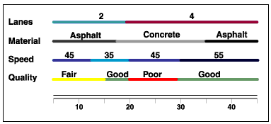
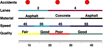
However, users often want to record many additional attributes about the roads. This could require that roads be split into many tiny segments at each location where attribute values change. As an alternative, these situations can be handled as linear referencing events along the roads as illustrated in the concept figure below:

Certain linear features also have attributes that change frequently—for example, observations that describe the condition of segments along key infrastructure networks (roads, pipes, and so on). Plus, these observations could be made repeatedly over time. For example, the pavement condition of a road changes as pavement deteriorates and is subsequently repaired. Linear referencing can be used to accurately locate multiple observations of the pavement condition, as illustrated below.

Segmenting linear features on a frequent basis becomes even more problematic when you consider that you may need to store other attributes. In addition to road conditions, you might also want to record traffic volumes, lane information, surface material, speed limits, and accident locations.
