In raster data, the cell typically represents the predominant feature or phenomenon of the area covered by a cell, whereas vector data can accurately delineate or identify individual features. As a result, when representing geographic features in a raster dataset, they become collections of cells with the same attribute values but lose their unique identities. Raster data is best used when your primary concern is with the locational relationships of the phenomena represented by geographic features and not the features themselves.
Points
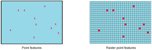
A point is represented by an explicit x,y coordinate in vector format, but as a raster, it is represented as a single cell—the smallest unit of a raster. By definition, a point has no area but is converted to a cell representing area. Therefore, the smaller the cell size, the smaller the area and, thus, the closer the representation of the point feature. For example, it is assumed that a well, a telephone pole, or the location of an endangered plant occupies the entire area covered by a cell.

With a cell representation of point data, there is some generalization of the original data. In general, if two or more points fall within the extent of a cell, ArcGIS randomly selects one of the points when assigning a value to the cell. However, when using the Point To Raster tool, you can choose the type of cell value assignment. It is possible to have fewer cells with values than there are points being converted.
Point data features will become the size of the cell. Thus, you should choose a cell size appropriate to the feature that the point represents. You should make your cell size small enough to capture sufficient input points for the desired analysis.
Learn more about converting from
- Raster data to point features using the Raster To Point tool
- Point features to raster data using the Point To Raster tool or Feature To Raster tool
Lines
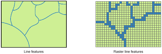
In vector format, a line is an ordered list of x,y coordinates, but in raster format, it is represented as a chain of spatially connected cells with the same value. When there is a break between the chain of same-valued cells, it represents a break in the line feature, which could represent different features such as two roads or two rivers that do not intersect.

Converting linear data to a raster dataset is similar to converting point data to a raster. For any line that passes within the extent of a cell, that cell will receive the value of the attribute identified in the conversion. If multiple lines pass through a single cell, ArcGIS will randomly select one of the lines to use to represent that cell location in the output raster dataset.
As with point data, linear features will become the width of the cell. For example, if the linear features that are being converted represent roads and the cell size is 1 kilometer, the road will be 1 kilometer wide in the output raster dataset. Obviously, a road is not 1 kilometer wide; thus, you should choose a cell size that is appropriate to the linear feature that you are representing. If the cell size is 1 meter, the road would be 1 meter wide.
Learn more about converting from
- Raster data to polyline features using the Raster To Polyline tool
- Polyline features to raster data using the Polyline To Raster tool or Feature To Raster tool
Polygons
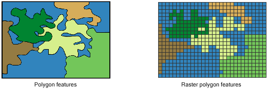
A vector polygon is an enclosed area defined by an ordered list of x,y coordinates in which the first and last coordinates are the same, thereby representing area. By contrast, a raster polygon is a group of contiguous cells with the same value that most accurately portray the shape of the area.
Polygonal, or area, data is best represented by a series of connected cells. Examples of polygonal features include buildings, ponds, soils, forests, swamps, and fields.
The accuracy of the raster representation below is dependent on the scale of the data and the size of the cell. The finer the cell resolution and the greater the number of cells that represent small areas, the more accurate the representation.

If the input data is polygonal, each cell on the resulting output raster dataset from the conversion process is assigned the value of the feature that fills the majority of the cell or that is encountered in the scan process within the cell (when using the ArcGIS Spatial Analyst extension).
Learn more about converting from
- Raster data to polygon features using the Raster To Polygon tool
- Polygon features to raster data using the Polygon To Raster tool or Feature To Raster tool