Available with 3D Analyst license.
One of the most important processes when creating a terrain dataset is to import source measurements correctly into a geodatabase feature dataset. Terrain datasets can be generated from several different types of data. Such data can include lidar and sonar points, breaklines and points derived from stereo photography, and other forms of survey data. The feature class geometry types supported for terrain datasets include points, multipoints, lines, and polygons. Source data used to generate a terrain dataset will come in either ASCII or LAS file formats.
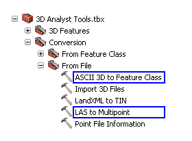
ASCII 3D To Feature Class and LAS To Multipoint are the two geoprocessing tools offered to import terrain source data into desired feature classes. These tools are available in the 3D Analyst toolbox. To ensure the toolbox is available, make sure the ArcGIS 3D Analyst extension is installed and enabled via the Customize > Extensions dialog box. Both tools can be found in the From File toolset of the 3D Analyst toolbox's Conversion toolset. The image below displays the location of the terrain dataset import tools in ArcToolbox.

Learn more about how to use the ASCII 3D to Feature Class tool
Learn more about how to use the LAS to Multipoint tool
3D ASCII source data
ASCII source data can be imported into feature classes using the ASCII 3D To Feature Class tool. This tool imports 3D features from one or more ASCII files into a new output feature class. The input format may be set to either XYZ, XYZI, or 3D GENERATE.
XYZ file format
The XYZ file format is the same for points, lines, and polygons in that each row of the source data file(s) is organized as x,y,z. The x,y,z values are double-precision floating point. Values can be space or comma delimited. Spaces are recommended. Header lines are permitted. The first line encountered where the first three tokens are numeric will be considered the beginning of the point records. Alphanumeric items after x-, y-, and z-coordinates are permitted, but they will not be used for anything. Only individual lines and polygons can be represented in an XYZ file, and they can only be single part. Polygons must close, with the last vertex equal to the first, and must not self-intersect.
XYZI file format
The XYZI file format is the same as the point xyz format explained above, with the addition of an intensity (i) field for each x,y,z location. The intensity is a value recorded by airborne lidar systems to represent the signal strength of the returned laser. It is often used to derive raster intensity imagery to depict the surface from which the lidar data was collected. The x,y,z,i values are double-precision floating point. Values can be space or comma delimited. Spaces are recommended.
3D GENERATE format
The 3D GENERATE format for points is the same as XYZ with the exception that no header lines are permitted, points are prefaced with IDs, and the last line of the file is optionally noted using the END keyword. The 3D GENERATE format for lines and polygons supports multiple features per file. Therefore, a feature can have several points along a vertex. The END keyword signals the end of a feature. Two END keywords in a row indicate the end of the file. Lines and polygons can only be single part. Polygons must close, with the last vertex equal to the first, and must not self-intersect.
LAS source data
The LAS file format is a open standard file format for the interchange of lidar data. It is a binary file format that maintains specific information related to lidar data. It is a way for vendors and clients to interchange data and maintain all information specific to that data. The LAS To Multipoint tool imports one or more LAS files into a multipoint feature class.
ArcGIS supports LAS versions 1.0, 1.1, 1.2, and 1.3. The waveform information that is available when using LAS version 1.3 is not supported. Additionally, LAS version 1.4 files that are 1.3 compliant.
Each LAS file contains metadata of the lidar survey in a header block followed by individual records for each laser pulse recorded. The header portion of each LAS file holds attribute information on the lidar survey itself: data extents, flight date, flight time, number of point records, number of points by return, any applied data offset, and any applied scale factor. The following lidar point attributes are maintained for each laser pulse of a LAS file: x,y,z location information, intensity, return number, number of returns, point classification values, scan angle, and scan direction.