A projected coordinate system is defined on a flat, two-dimensional surface. Unlike a geographic coordinate system, a projected coordinate system has constant lengths, angles, and areas across the two dimensions. A projected coordinate system is always based on a geographic coordinate system that is based on a sphere or spheroid.
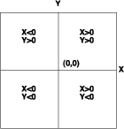
In a projected coordinate system, locations are identified by x,y coordinates on a grid, with the origin at the center of the grid. Each position has two values that reference it to that central location. One specifies its horizontal position and the other its vertical position. The two values are called the x-coordinate and y-coordinate. Using this notation, the coordinates at the origin are x = 0 and y = 0.
On a gridded network of equally spaced horizontal and vertical lines, the horizontal line in the center is called the x-axis and the central vertical line is called the y-axis. Units are consistent and equally spaced across the full range of x and y. Horizontal lines above the origin and vertical lines to the right of the origin have positive values; those below or to the left have negative values. The four quadrants represent the four possible combinations of positive and negative X and Y coordinates.
When working with data in a geographic coordinate system, it is sometimes useful to equate the longitude values with the X axis and the latitude values with the Y axis.

Lists of the supported projected coordinate systems are available in a projected_coordinate_systems.pdf file in the ArcGIS Documentation folder.