Generate creates coverages from raw coordinates stored in a text file. Any coordinate data can be loaded as long as the coordinates are put into the appropriate Generate format. For example, to generate lines, create a text file that has a User-ID number for each line, followed by the series of x,y coordinate pairs that define the line. The exact formats for these files are described for each feature type.
Annotations
Adds annotations to the coverage.
The format for annotation coordinates is:
<ID> <X> <Y> <angle> <size> <text...>
end
- ID—The ID number for the annotation being added.
- X and Y—Identifies the coverage coordinates for the lower left beginning point of the text string being entered.
- angle—The text angle given in degrees counterclockwise from the horizontal, which is zero degrees. If the angle is zero, generated annotation will be one-point annotation. If the angle is not zero, generated annotation is two-point annotation.
- size—The annotation height in coverage units.
- text—The text string to be generated (up to 80 characters in length). To continue a text string on another line, end the first line with a continuation character: ~.
- The end statement signifies the end of feature coordinates.
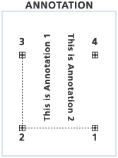
An example of annotation coordinate format:
1 2 1 90 .3 This is annotation 1
2 3 4 -90 .3 This is annotation 2
end
Circles
Generates circles, each with a specified center and radius.
The format for circle coordinates is:
<ID> <X> <Y> <radius>
end
- ID—The ID number for the circle being added.
- X and Y—Identifies the coverage coordinates for the center of the circle.
- radius—The radius of the circle specified in coverage units.
- The end statement signifies the end of feature coordinates.
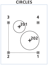
An example of circle coordinate format:
201, 3, 7, 2.0
202, 9, 4, 3.0
end
Curves
Generates curves from three points: the starting point, the center point, and the ending point.
The format for curve coordinates is:
<ID> <start_point> <center_point> <end_point>
end
- ID—The ID number for the curve being added.
- start_point—Identifies the coverage coordinates for the starting point of the curve.
- center_point—Identifies the coverage coordinates for the center point of the curve.
- end_point—Identifies the coverage coordinates for the ending point of the curve.
- The end statement signifies the end of feature coordinates.
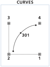
An example of curve coordinate format:
301, 1,0 2,2 5,3
end
Fishnet
Creates a fishnet of rectangular cells. Nodes are created at intersection points of each cell. The following coordinate file format defines fishnet output:
- Fishnet origin coordinate (X, Y)—The lower left corner of the fishnet.
- Y-axis coordinate (X, Y)—A point on the positive y-axis from the origin point used to orient the fishnet.
- Cell size (Width, Height)—The size of the cells in the x and y directions. Cell sizes are expressed in coverage units and should reflect the map projection of the coverage. For example, a cell size of 0.5 is half of a degree in geographic, but 0.5 meters in UTM.
- Number of rows, columns used with the cell size to determine the size of the fishnet.
- Opposite corner of fishnet (X,Y)—The coordinates of the opposite corner of the fishnet.
If zero is specified for the cell size, then it will be automatically computed based on the next two lines in the coordinate file: the numbers of rows and columns and the opposite corner of the fishnet.
If the cell size has a value greater than zero and if the line for the number of rows and columns equals zero, then the next line in the coordinate file specifies the opposite corner of the fishnet. The specified cell size will be used to automatically calculate how many rows and columns can fit within the area defined by the origin and the upper-right corner without exceeding the corner coordinates.
The following chart describe the coordinate format for different cell size values.
| Cell Size | Cell Size = 0 |
|---|---|
0,1 - fishnet origin coordinate (X,Y) | 0,0 - Fishnet origin coordinate (X,Y) |
1,1 - Y- axis coordinate (X,Y) | 0,1 - Y- axis coordinate (X,Y) |
4,4 - Cell size (width, height) | 0 - Cell size (width,height) |
4,4 - Number of (rows, columns) | 4,4 - Number of (rows, columns) |
4,4 - Opposite corner of fishnet (X,Y) |
Examples
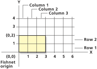
In this example, a fishnet with two rows and three columns is generated. The fishnet origin is (0,0); (0,2) is a point that lies on the positive y-axis of the fishnet, with a cell size of 1 (width) by 1 (height), and with two rows and three columns.
0,0
0,2
1,1
2,3
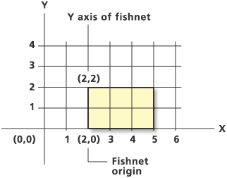
In this example, the fishnet origin is shifted to (2,0), and (2,2) is a point that lies on the y-axis of the fishnet. The orientation of the y-axis of the fishnet could also have been defined with other points like (2,1), (2,3), (2,4), and so on.
2,0
2,2
1,1
2,3
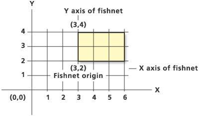
In this example, the fishnet origin is shifted to (3,2). Notice how the x-axis and y-axis of the fishnet change accordingly.
3,2
3,4
1,1
2,3
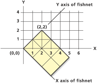
In this example, the fishnet origin is kept at (0,0). However, the y-axis of the grid is rotated relative to the y-axis of the Cartesian coordinate system. (2,2) is a point that lies on the y-axis of the rotated fishnet. The rotation of the y-axis of the fishnet could also have been defined using the points (1,1), (3,3), (4,4), and so on, in place of (2,2). Any point that falls on the positive y-axis of the fishnet will work.
0,0
2,2
1.414,1.414
2,3
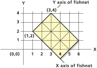
In this example, the fishnet origin is moved to (1,2). As in the previous example, the y-axis of the fishnet is rotated 45 degrees. (3,4) defines a point on the positive y-axis of the fishnet.
1,2
3,4
1.414,1.414
2,3
The following three examples show different methods to generate a 4x4 fishnet.
Specify cell size and number of rows/columns:
0,0
0,1
1,1
4,4
Specify number of rows/columns and opposite corner of fishnet. Cell size is set to zero.
0,0
0,1
0
4,4
4,4
Specify cell size and opposite corner of fishnet. The number of r+ows/columns is set to zero.
0,0
0,1
1,1
0
4,4
Lines
Adds arcs to the coverage.
The format for line coordinates is:
<ID>
<X,Y>
end
end
- ID—The ID number for the line feature being added.
- X and Y—The x,y coordinate pairs for each vertex, one pair per line. The coordinates of each pair may be separated with a comma or space.
- end—Specifies end of line feature.
- end—Specifies end of coordinates in file.
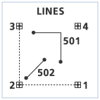
An example of line coordinate format:
501
2,8
5,8
5,5
end
502
1,2
4,5
end
end
Links
Adds links to the coverage.
The format for link coordinates is:
<ID>
<X,Y>
<X,Y>
end
end
- ID—The ID number for the link feature being added.
- X and Y—The x,y coordinate of the first point that defines the link, one pair per line. The coordinates of each pair may be separated by comma or space.
- X and Y—The x,y coordinate of the second point that defines the link, one pair per line. The coordinates of each pair may be separated by comma or space.
- end—Specifies end of link coordinates.
- end—Specifies end of coordinates in file.
An example of link coordinate format:
3,10.5
6,10.5
3,0
4,0
end
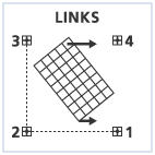
A check is made to ensure that two coordinate pairs are entered for each link. Identity links can be added by specifying the same coordinates for both x,y pairs.
Points
Adds label points to the coverage.
The format for point coordinates is:
<ID> <X,Y> {Angle} {Scale}
end- ID—The ID number for the point feature being added.
- X and Y—The x,y coordinate of the point feature.
- Angle—The angle of the point feature in decimal degrees. The default angle is 0.
- Scale—The scale of the point feature. The default scale is 1.
- end—Specifies end of coordinates in file.
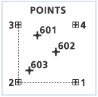
Generate a simple point cover allowing the {Angle} and {Scale} parameters to default to 0 and 1:
601,3,7
602,9,7
603,5,4
end
Generate a point cover specifying values for {Angle} and {Scale} for each point:
601,3,7,45,2.5
602,9,7,-30,0.5
603,5,4,90,1.5
end
Polygons
Adds polygons and label points to the coverage.
The format for POLYGON coordinates is:
<ID> {AUTO | X,Y>}
X,Y
end
end- <ID> , {AUTO | X,Y>}ID—The ID number for the polygon feature and the x,y coordinates for the polygon label. If no X,Y value is specified, then the default AUTO option is used to automatically place the polygon label. Do not use a POLYGON-ID = -99999. This has a special meaning. Ungenerate Polygons flags all island polygons with this special ID. Generate Polygons will ignore all polygons with an ID of -99999.
- X,Y—The x,y coordinate of the next vertex of the polygon. Specify one coordinate pair per line. Multiple coordinate pairs may be entered on a single line if they are separated by a semicolon.
- end—Specifies end of polygon coordinates. Polygons will be closed automatically from the last vertex entered to the first vertex if the two vertices are not the same.
- end—Specifies end of coordinates in file.
Generate a polygon with a specified label point:
701,7,7
3,9
4,5
8,4
9,7
6,9
3,9
end
end
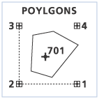
In this example, the code automatically generates the polygon label point and adds the closing vertex.
701, auto
3,9
4,5
8,4
9,7
6,9
end
end
Tics
Adds tics to the coverage.
The format for adding TICS coordinates is:
<ID> <X,Y>
end
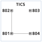
Enter one tic per line by specifying the User-ID and the x,y coordinates for each tic. Use END to specify end of tic coordinates in the file. The following example adds four tics to the output coverage:
801,0,0
802,0,10
803,10,10
804,10,0
end
