 |
This document is archived and information here might be outdated. Recommended version. |
 |
This document is archived and information here might be outdated. Recommended version. |
| ArcObjects Help for .NET developers > ArcObjects namespaces > Geometry > ESRI.ArcGIS.Geometry > Interfaces > IP > IPolycurve Interface > IPolycurve.Densify Method (ArcObjects .NET 10.5 SDK) |
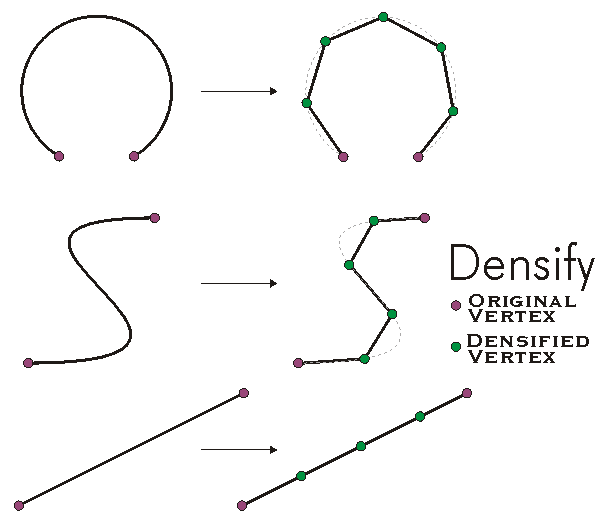
Converts this polycurve into a piecewise linear approximation of itself.
[Visual Basic .NET]
Public Sub Densify ( _
    ByVal maxSegmentLength As Double, _
    ByVal maxDeviation As Double _
)
[C#]
public void Densify (
    double maxSegmentLength,
    double maxDeviation
);
[C++]
HRESULT Densify(
  double maxSegmentLength,
  double maxDeviation
);
[C++]

Parameters
maxSegmentLength
  maxSegmentLength is a parameter of type double
maxDeviation
  maxDeviation is a parameter of type double
Converts Polycurve into a Polycurve composed of Line segments with length maxSegmentLength (or less) that are within maxDeviation of the original polycurve. If maxDeviation=0, maxDeviation is ignored and Line segments with length maxSegmentLength are constructed with vertices laying on the original curve. All of the segments in the final polyline will be Lines.
If the maxSegmentLength is negative IGeometryEnvironment::AutoDensifyTolerance is used. IGeometryEnvironment::AutoDensifyTolerance default value is 0. This value can be explicitly set via IGeometryEnvironment::AutoDensifyTolerance.
If the maxDeviation is negative IGeometryEnvironment::DeviationAutoDensifyTolerance is used. The default value is 2*XYResolution * 100 (2/XYUnits * 100). This value can be explicitly set via IGeometryEnvironment::DeviationAutoDensifyTolerance.
In order to avoid the creation of too many segments, the geometry system uses a maxdeviation=2*xyResolution * 100 as default value if maxSegmentLength is 0 and the maxDeviation is 0.
If the maxDeviation is positive but smaller than 2*XYResolution of the spatial reference then the maxDeviation used is 2*XYResolution * 100
NOTE: The default values given in this topic are subject to change without notice. If specific values want to be maintained we recommend using the methods on IGeometryEnvironment to set those explicitly.
The start and end points are always honored and remain the same as for the original feature.
