| ArcObjects Library Reference (Geometry) |
|
ITopologicalOperator.Simplify Method
Makes this geometry topologically correct.
[Visual Basic .NET]
Public Sub Simplify ( _
)
[C#]
public void Simplify (
);
[C++]
HRESULT Simplify(
void
);
Product Availability
Available with ArcGIS Engine, ArcGIS Desktop, and ArcGIS Server.
Description
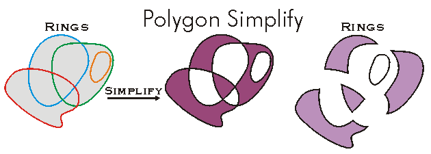
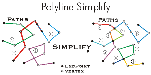
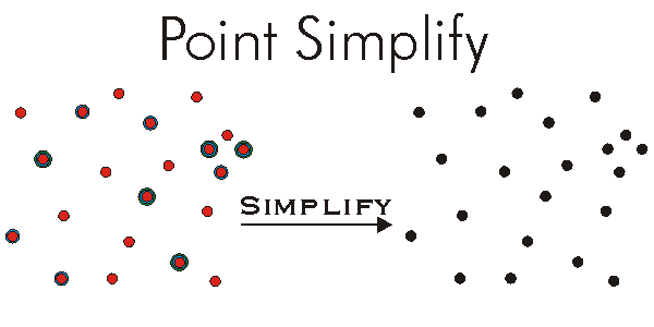
Simplify permanently alters the input geometry, making its definition "topologically legal" with respect to its geometry type:
- For Points, Simplify does nothing. A point has no constraints on the values of its coordinates.
- For Multipoints, Simplify snaps all X, Y, Z, and M coordinates to the grid of the associated spatial reference, then removes identical points. A point is identical to another point when the two have identical X and Y coordinates (after snapping), and when attributes for which it is aware are identical to the attributes for which the other point is aware. For example, if both points are Z aware, the Z coordinate values must be identical.
- For Polylines, Simplify has two variations: planar and non-planar. By default, polylines that are not M-aware are simplified in a planar manner: all overlapping segments are reduced to a single segment, and segments are split at intersection points. Output paths are created for connected sequences of segments. Input segment orientation is preserved where possible, but segments in the interior of a path will be reoriented if necessary. Polylines that are M-aware use non-planar simplification: 1. Overlaps and self-intersections are preserved, but zero length segments are removed, 2. Segment orientations are adjusted so that the 'to' point of segment I is identical to (considering vertex attributes) the 'from' point of Segment I+1, 3. New paths are created where segments are not connected, 4. Existing paths are merged where only two of them meet at a segment endpoint.
- For Polygons, Simplify identifies an interior and exterior for the polygon, then modifies the polygon structure to be consistent with that determination. The default methodology for identifying interior and exterior is: 1. Remove all dangling sequences of segments, 2. Identify the largest legal rings, add them to the output version of the polygon, then delete them from the working version, 3. Repeat. If this approach ends up removing too many segments for your application, consider using IPolygon4::SimplifyEx with the XOR parameter set to TRUE. At the end of Simplify, no rings will overlap, no self intersection will occur (except in certain circumstances) and, in general, an arbitrary point can always be classified unambiguously as either outside, on the boundary of, or inside the polygon.
The XY tolerance property of the geometry's associated spatial reference is used during the simplify operation for polylines and polygons.
Remarks
This method first looks at the ITopologicalOperator::IsKnownSimple flag before starting processing. If the flag is 'true' then operation is interrupted and the geometry is considered simple. If the flag is 'false' then the geometry consistency is checked and the geometry is updated as needed.
ITopologicalOperator methods must be applied on high-level geometries only. High-Level geometries are point, multipoint, polyline and polygon. To use this method with low-level geometries such as segments (Line, Circular Arc, Elliptic Arc, Bézier Curve), paths or rings, they must be wrapped into high-level geometries types.


See Also
ITopologicalOperator Interface
.NET Samples
3D multipatch examples (Code Files:
ExtrusionExamples)
.NET Related Topics
Creating custom symbols |
How to create a multipoint |
How to create a polygon |
How to create a polyline |
Simplifying a feature geometry |
Working with the edit sketch


