|
This document is archived and information here might be outdated. Recommended version. |
IGeometryServer2.DensifyGeodesic Method (ArcObjects .NET 10.8 SDK)
|
This document is archived and information here might be outdated. Recommended version. |
Densifies geometries by plotting points along the geodesics between existing vertices (uses IPolycurve4::GeodesicDensify).
[Visual Basic .NET]
Public Function DensifyGeodesic ( _
    ByVal pSR As ISpatialReference, _
    ByVal pInGeometries As IGeometryArray, _
    ByVal maxSegmentLength As Double, _
    ByVal pLengthUnit As ILinearUnit _
) As IGeometryArray
[C#]
public IGeometryArray DensifyGeodesic (
    ISpatialReference pSR,
    IGeometryArray pInGeometries,
    double maxSegmentLength,
    ILinearUnit pLengthUnit
);
[C++]
HRESULT DensifyGeodesic(
  ISpatialReference* pSR,
  IGeometryArray* pInGeometries,
  double maxSegmentLength,
  ILinearUnit* pLengthUnit
);
[C++]
Parameters
pSR

  pSR is a parameter of type ISpatialReference*
pInGeometries

  pInGeometries is a parameter of type IGeometryArray*
maxSegmentLength

  maxSegmentLength is a parameter of type double
pLengthUnit

  pLengthUnit is a parameter of type ILinearUnit*
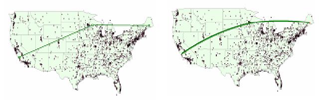
Densifies each polyline or polygon in the input array by plotting points along the geodesic paths between existing vertices. MaxSegmentLength is expressed in some linear unit of measure. If the LengthUnit parameter is specified, then MaxSegmentLength is expressed in those units. If the LengthUnit parameter is not specified, then MaxSegmentLength is expressed in the the linear units of the input spatial reference, if the spatial reference is a projected coordinate system. Otherwise, it is assumed to be expressed in meters.
If the spatial reference is a projected coordinate system, then the input geometries will be inversed projected, geodesic path points will be plotted, and the result will be forward projected into the same spatial reference.
The figure below illustrates the DensifyGeodesic operation applied to a polyline with 3 vertices, with a max output segment length of 10,000 meters.