ArcGIS for Desktop

  • Documentación
  • Precios
  • Soporte

  • My Profile
  • Ayuda
  • Sign Out
ArcGIS for Desktop

ArcGIS Online

La plataforma de representación cartográfica para tu organización

ArcGIS for Desktop

Un completo SIG profesional

ArcGIS for Server

SIG en tu empresa

ArcGIS for Developers

Herramientas para crear aplicaciones basadas en la ubicación

ArcGIS Solutions

Plantillas de aplicaciones y mapas gratuitas para tu sector

ArcGIS Marketplace

Obtén aplicaciones y datos para tu organización.

  • Documentación
  • Precios
  • Soporte
Esri
  • Iniciar sesión
user
  • Mi perfil
  • Cerrar sesión

Help

  • Inicio
  • Introducción
  • Mapa
  • Analizar
  • Administrar datos
  • Herramientas
  • Más...

Understanding universal kriging

Disponible con una licencia de Geostatistical Analyst.

Universal kriging assumes the model

Z(s) = µ(s) + ε(s),

where µ(s) is some deterministic function. For example, in the following figure, which has the same data that was used for ordinary kriging concepts, the observed data is given by the solid circles.
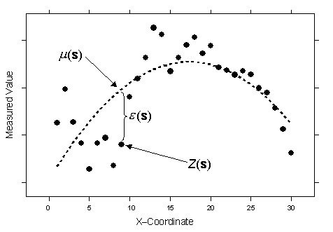
Universal kriging

A second-order polynomial is the trend—long dashed line—which is µ(s). If you subtract the second-order polynomial from the original data, you obtain the errors, ε(s), which are assumed to be random. The mean of all ε(s) is 0. Conceptually, the autocorrelation is now modeled from the random errors ε(s). Of course, you could have fit a linear trend, a cubic polynomial, or any number of other functions. The figure above looks just like a polynomial regression from any basic statistics course. In fact, that is what universal kriging is. You are doing regression with the spatial coordinates as the explanatory variables. However, instead of assuming the errors ε(s) are independent, you model them to be autocorrelated. The advice is the same as for ordinary kriging: there is no way to decide, based on the data alone, on the proper decomposition.

Universal kriging can use either semivariograms or covariances (which are the mathematical forms you use to express autocorrelation), use transformations, and allow for measurement error.

Temas relacionados

  • Using universal kriging to create a prediction map
  • Using universal kriging to create a prediction standard error map
¿Algún comentario sobre este tema?

ArcGIS for Desktop

  • Inicio
  • Documentación
  • Precios
  • Soporte

Plataforma ArcGIS

  • ArcGIS Online
  • ArcGIS for Desktop
  • ArcGIS for Server
  • ArcGIS for Developers
  • ArcGIS Solutions
  • ArcGIS Marketplace

Acerca de Esri

  • Quiénes somos
  • Empleo
  • Blog interno
  • Conferencia de usuarios
  • Cumbre de desarrolladores
Esri
© Copyright 2016 Environmental Systems Research Institute, Inc. | Privacidad | Legal