ArcGIS for Desktop

  • Documentación
  • Precios
  • Soporte

  • My Profile
  • Ayuda
  • Sign Out
ArcGIS for Desktop

ArcGIS Online

La plataforma de representación cartográfica para tu organización

ArcGIS for Desktop

Un completo SIG profesional

ArcGIS for Server

SIG en tu empresa

ArcGIS for Developers

Herramientas para crear aplicaciones basadas en la ubicación

ArcGIS Solutions

Plantillas de aplicaciones y mapas gratuitas para tu sector

ArcGIS Marketplace

Obtén aplicaciones y datos para tu organización.

  • Documentación
  • Precios
  • Soporte
Esri
  • Iniciar sesión
user
  • Mi perfil
  • Cerrar sesión

Help

  • Inicio
  • Cómo empezar
  • Mapa
  • Analizar
  • Administrar datos
  • Herramientas
  • Más...

Spatial Query rule sample results

The following sample shows the results of a Spatial Query rule execution on a diagram.

For the schematic diagram template implementing the following sample diagram (figure 1.1), a Spatial Query rule is defined to automatically detect and add the secondary network features that are close to the TransformerBank features initially used to generate the diagrams. The TransformerBank features are the schematic features displayed in blue in the sample diagram below.
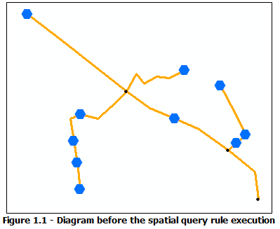
Diagram sample, initial content

The Spatial Query rule attributes are specified so that only the SecondaryLine schematic links whose associated features are within a distance of 1 meter from the initial TransformerBank features are retrieved and added to the generated schematic diagram. Then, as the Standard builder options for the diagram template specify that connected nodes are automatically retrieved and added for any link (the Add connected nodes option is checked), the origin or extremity nodes that connect the added SecondaryLine links to the initial TransformerBank features are also automatically added during rule execution:
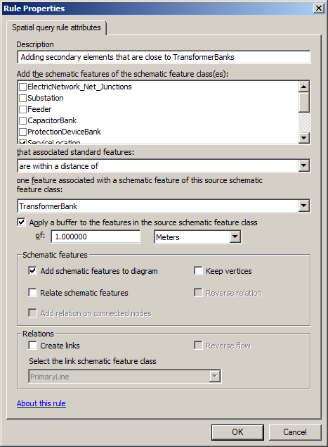
Spatial Query rule properties page specified to add secondary elements that are close to TransformerBank features

Figure 1.2 shows the result obtained after updating the diagram while this Spatial Query rule is active. When SecondaryLine edges are close to TransformerBank features, the rule automatically retrieves these edges and their connected service locations (gray circles) so the topology is preserved and creates the associated schematic features in the generated diagram:
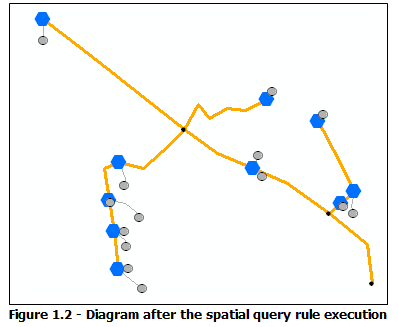
Diagram sample, result after the Spatial Query rule execution

Temas relacionados

  • Operating Spatial Query rules
¿Algún comentario sobre este tema?

ArcGIS for Desktop

  • Inicio
  • Documentación
  • Precios
  • Soporte

Plataforma ArcGIS

  • ArcGIS Online
  • ArcGIS for Desktop
  • ArcGIS for Server
  • ArcGIS for Developers
  • ArcGIS Solutions
  • ArcGIS Marketplace

Acerca de Esri

  • Quiénes somos
  • Empleo
  • Blog interno
  • Conferencia de usuarios
  • Cumbre de desarrolladores
Esri
© Copyright 2016 Environmental Systems Research Institute, Inc. | Privacidad | Legal