Disponible con una licencia Advanced.
Resumen
Determines the distances from input point features to all points in the near features within a specified search radius.
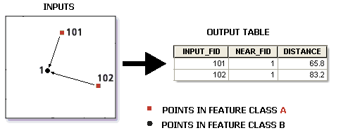
Ilustración

Uso
The tool creates a table with distances between two sets of points. if the default search radius is used, distances from all input points to all near points are calculated. The output table can be quite large. For example, if both input and near features have 1,000 points each, then the output table can contain one million records.
Use a meaningful search radius to limit the size of the output and improve tool performance. The output table contains only those records that have a near point within the search radius.
The results are recorded in the output table containing the following information:
- INPUT_FID: The feature ID of the input features
- NEAR_FID: The feature ID of the near features
- DISTANCE: The distance from the input to near feature. The value of this field is in the linear unit of the input features coordinate system.
Tanto las Entidades de entrada como las Entidades próximas pueden estar en el mismo dataset. En ese caso, cuando las entidades de entrada y las entidades próximas están en el mismo registro, el resultado se omitirá para no tener que informar que cada entidad está a 0 unidades de sí misma.
Sintaxis
PointDistance_analysis (in_features, near_features, out_table, {search_radius})| Parámetro | Explicación | Tipo de datos |
in_features | The point features from which distances to the near features will be calculated. | Feature Layer |
near_features | The points to which distances from the input features will be calculated. Distances between points within the same feature class or layer can be determined by specifying the same feature class or layer for the input and near features. | Feature Layer |
out_table | The table containing the list of input features and information about all near features within the search radius. If a search radius is not specified, distances from all input features to all near features are calculated. | Table |
search_radius (Opcional) | Specifies the radius used to search for candidate near features. The near features within this radius are considered for calculating the nearest feature. If no value is specified (that is, the default (empty) radius is used) all near features are considered for calculation. The unit of search radius defaults to units of the input features. The units can be changed to any other unit. However, this has no impact on the units of the output DISTANCE field which is based on the units of the coordinate system of the input features. | Linear unit |
Ejemplo de código
PointDistance example 1 (Python window)
The following Python interactive window script demonstrates how to use the PointDistance function in immediate mode.
import arcpy
arcpy.env.workspace = "C:/data/pointdistance.gdb"

arcpy.PointDistance_analysis("police_stations", "crime_location", "crime_distances")
PointDistance example 2 (stand-alone Python script)
The following Python script demonstrates how to use the PointDistance function in a stand-alone script.
# Description: Finds distance of each near point from each input point and outputs to a table.

# import system modules
import arcpy

# set workspace environment
arcpy.env.workspace = "C:/data/pointdistance.gdb"

# set variables
in_features = "police_stations"
near_features = "crime_location"
out_table = "crime_distance4"
search_radius = "22000 Feet"

# find crime locations within the search radius
arcpy.PointDistance_analysis(in_features, near_features, out_table, search_radius)
Entornos
Información sobre licencias
- ArcGIS for Desktop Basic: No
- ArcGIS for Desktop Standard: No
- ArcGIS for Desktop Advanced: Sí