Resumen
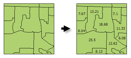
Calculates area values for each feature in a polygon feature class.
Ilustración

Uso
The F_AREA field created in the Output Feature Class will be populated with values for the area of each polygon feature in square units of the Output Coordinate System.
There are alternative methods for creating an Area field for polygon features including: Calculate Field and the Geometry Calculator.
The Output Feature Class is a copy of the Input Feature Class with the additional (or updated) F_AREA field containing polygon areas.
Sintaxis
CalculateAreas_stats (Input_Feature_Class, Output_Feature_Class)
| Parámetro | Explicación | Tipo de datos |
Input_Feature_Class | The input polygon feature class. | Feature Layer |
Output_Feature_Class | The output feature class. This feature class is a copy of the input feature class with field F_AREA added (or updated). The F_AREA field contains the polygon area. | Feature Class |
Muestra de código
CalculateAreas Example (Python Window)
The following Python Window script demonstrates how to use the CalculateAreas tool.
import arcpy
arcpy.env.workspace = "c:/data"
arcpy.CalculateAreas_stats("tracts.shp", "tracts_with_area_field.shp")
CalculateAreas Example (stand-alone Python script)
The following stand-alone Python script demonstrates how to use the CalculateAreas tool.
# Calculate AREA values

# Import system modules
import arcpy

# Local variables...
workspace = "C:/data"
input = "tracts.shp"
calculate_output = "tracts_with_area_field.shp"

try:
    # Set the current workspace (to avoid having to specify the full path to the feature classes each time)
    arcpy.env.workspace = workspace

    # Process: Calculate Areas...
    arcpy.CalculateAreas_stats(input, calculate_output)

except:
    # If an error occurred when running the tool, print out the error message.
    print arcpy.GetMessages()
Entornos
Información sobre licencias
- ArcGIS Desktop Basic: Sí
- ArcGIS Desktop Standard: Sí
- ArcGIS Desktop Advanced: Sí