Resumen
Gets a local copy of a file stored inside the Product Library. It allows you to view or edit a file without exclusively locking the file in a Product Library. Changes made to the local copy are not tracked in the Product Library.
Una biblioteca del producto almacena la información y los datos necesarios para la producción de datos cartográficos y digitales en una geodatabase. Esri Mapping and Charting solutions almacenan información espacial, documentos y reglas comerciales en una biblioteca del producto.
Uso
El Espacio de trabajo de la Biblioteca de productos debe ser una geodatabase.
The file must be contained within the Product Library.
The Copy Location must be a folder on the user’s local computer.
The Product Library File Path is the path to the particular Product Library tree node. A product library path is a double-colon-delimited string (::) in this format: Solution Name::Product Class Name::Series Name::Product Name::Instance Name::AOI Name::File Name.
Para determinar la ruta de la biblioteca de productos, desplácese hasta un elemento de la ventana Biblioteca de productos, haga clic en el mismo con el botón secundario y, a continuación, haga clic en Copiar como ruta. ruta de la biblioteca de productos debe encontrarse en el Portapapeles. Podrá pegarla en cualquier parámetro que requiera una ruta de la biblioteca de productos.
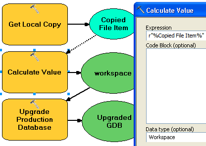
This tool returns a string that represents a path to the local copy. To use this tool in ModelBuilder, insert the Calculate Value tool to convert the returned string to another data type. For example, to create a model that gets a local copy of an instance database and upgrades it using the Upgrade Production Database tool, connect Get Local Copy to Calculate Value through a precondition. Calculate Value can convert the string returned by Get Local Copy to a workspace. The model would look similar to the following image:

Sintaxis
PLGetLocalCopy(product_library_workspace, product_library_itempath, copy_location, {product_library_ownername})| Parámetro | Explicación | Tipo de datos |
product_library_workspace | Ruta al espacio de trabajo de biblioteca del producto. | Workspace |
product_library_itempath | The path to the product library level that contains the files you want to view. This is specified as Solution Name::Product Class Name::Series Name::Product Name::Instance Name::AOI Name::File Name. | String |
copy_location | The folder to where the file will be copied. Any existing local copies of the file will be overwritten. | Folder |
product_library_ownername (Opcional) | Nombre del propietario del esquema de biblioteca de productos. Configure este parámetro si la cuenta de usuario especificada en el product_library_workspace no es el propietario del esquema. Esto es aplicable solamente a bibliotecas de productos almacenadas en geodatabases corporativas. | String |
Muestra de código
PLGetLocalCopy example (stand-alone script)
The following stand-alone script demonstrates how to use the PLGetLocalCopy tool.
# Name: GetLocalCopy_Example.py
# Description: Creates a local, editable copy of a file in a product library.
# Requirements: Production Mapping extension

# import arcpy and checkout a Production Mapping license
import arcpy
arcpy.CheckOutExtension("foundation")

#Set local variables
product_library_workspace = "C:\\Data\\ProductLibrary.gdb"
product_library_itempath = "Products::Topographic Maps::QA_QC_carto_checklist.rtf"
copy_location = "C:\\Data"

# create a production database
arcpy.PLGetLocalCopy_production(product_library_workspace, product_library_itempath, copy_location)

print "Script completed successfully."

# Check in the extension
arcpy.CheckInExtension("foundation")
Entornos
Información sobre licencias
- ArcGIS Desktop Basic: No
- ArcGIS Desktop Standard: Requiere Production Mapping
- ArcGIS Desktop Advanced: Requiere Production Mapping