Disponible con licencia de Production Mapping.
Resumen
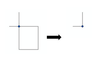
This tool removes self-intersecting portions of features beyond their vertices of intersection in an input line or polygon feature class.
Ilustración

Uso
This tool modifies the input features.
Sintaxis
RemoveSelfIntersections(Input_Features, {Maximum_Removal_Length}, {Remove_Self_Intersections_at_End_Point}, {Check_for_Errors_Only}, {Output_Table})| Parámetro | Explicación | Tipo de datos |
Input_Features | The polyline or polygon feature class from which this tool will remove self-intersections. This feature class (or layer) will be modified. | Feature Layer |
Maximum_Removal_Length (Opcional) | The maximum length for input lines or polygons. Features within maximum length are deleted. | Linear unit |
Remove_Self_Intersections_at_End_Point (Opcional) | Indicates if this tool will remove, or avoid removing, any self-intersections whose end point is snapped on itself.
| Boolean |
Check_for_Errors_Only (Opcional) | Indicates if this tool will report errors only or remove self-intersections.
| Boolean |
Output_Table (Opcional) | The table that will be created containing all errors if REPORT_ONLY is selected in the Check_For_Errors_Only parameter. | Feature Layer |
Muestra de código
RemoveSelfIntersections example 1 (stand-alone script)
The following stand-alone sample script demonstrates how to use the RemoveSelfIntersections tool.
# Name: RemoveSelfIntersections_Example.py
# Description: Remove the self-intersections in the roads feature class that are under 50 meters long.  No warnings or errors will be recorded in a table.

# Import system modules
import arcpy

# Check out extension
arcpy.CheckOutExtension("Foundation")

# Define variables
input_features = r"C:\data\Edit_Sample.gdb\Roads"
maximum_removal_length = "50 Meters"

# Execute Remove Self Intersections
arcpy.RemoveSelfIntersections_production(input_features, maximum_removal_length, "REMOVE_SNAPPED", "REPAIR_ONLY", "#")

# Check in Production Mapping license
arcpy.CheckInExtension("Foundation")
Entornos
Información sobre licencias
- ArcGIS Desktop Basic: No
- ArcGIS Desktop Standard: Requiere Production Mapping
- ArcGIS Desktop Advanced: Requiere Production Mapping