ArcGIS Desktop

  • Documentación
  • Soporte

  • My Profile
  • Ayuda
  • Sign Out
ArcGIS Desktop

ArcGIS Online

La plataforma de representación cartográfica para tu organización

ArcGIS Desktop

Un completo SIG profesional

ArcGIS Enterprise

SIG en tu empresa

ArcGIS for Developers

Herramientas para crear aplicaciones basadas en la ubicación

ArcGIS Solutions

Plantillas de aplicaciones y mapas gratuitas para tu sector

ArcGIS Marketplace

Obtén aplicaciones y datos para tu organización.

  • Documentación
  • Soporte
Esri
  • Iniciar sesión
user
  • Mi perfil
  • Cerrar sesión

ArcMap

  • Inicio
  • Introducción
  • Cartografiar
  • Analizar
  • Administrar datos
  • Herramientas
  • Extensiones

Calculate Areas

  • Resumen
  • Ilustración
  • Uso
  • Sintaxis
  • Muestra de código
  • Entornos
  • Información sobre licencias

Resumen

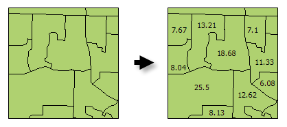
Calculates area values for each feature in a polygon feature class.

Legado:

Because there are easier and more efficient ways to get the area of features, the Calculate Areas tool has been deprecated. Use the Calculate Field tool or the Geometry Calculator instead of the Calculate Areas tool in your workflows and custom script or models tools. If you are using feature classes in a geodatabase, the shape_area attribute field is maintained for you automatically.

Ilustración

Calculate Areas illustration

Uso

  • The F_AREA field created in the Output Feature Class will be populated with values for the area of each polygon feature in square units of the Output Coordinate System.

  • There are alternative methods for creating an Area field for polygon features including: Calculate Field and the Geometry Calculator.

  • The Output Feature Class is a copy of the Input Feature Class with the additional (or updated) F_AREA field containing polygon areas.

  • Precaución:

    The F_AREA field is created in the Output Feature Class to store calculated Area values. If a field of this name already exists in the Input Feature Class, it will be overwritten in the Output Feature Class.

    Precaución:

    Al utilizar shapefiles tenga en cuenta que no pueden almacenar valores nulos. Las herramientas u otros procedimientos que crean shapefiles a partir de entradas sin shapefiles pueden almacenar o interpretar valores nulos como cero. En algunos casos, los nulos se almacenan como valores negativos muy grandes en shapefiles. Esto puede ocasionar resultados inesperados. Consulte Consideraciones de geoprocesamiento para la salida del shapefile para obtener más información.

Sintaxis

CalculateAreas_stats (Input_Feature_Class, Output_Feature_Class)
ParámetroExplicaciónTipo de datos
Input_Feature_Class

The input polygon feature class.

Feature Layer
Output_Feature_Class

The output feature class. This feature class is a copy of the input feature class with field F_AREA added (or updated). The F_AREA field contains the polygon area.

Feature Class

Muestra de código

CalculateAreas Example (Python Window)

The following Python Window script demonstrates how to use the CalculateAreas tool.

import arcpy
arcpy.env.workspace = "c:/data"
arcpy.CalculateAreas_stats("tracts.shp", "tracts_with_area_field.shp")
CalculateAreas Example (stand-alone Python script)

The following stand-alone Python script demonstrates how to use the CalculateAreas tool.

# Calculate AREA values
 
# Import system modules
import arcpy
 
# Local variables...
workspace = "C:/data"
input = "tracts.shp"
calculate_output = "tracts_with_area_field.shp"
 
try:
    # Set the current workspace (to avoid having to specify the full path to the feature classes each time)
    arcpy.env.workspace = workspace
 
    # Process: Calculate Areas...
    arcpy.CalculateAreas_stats(input, calculate_output)
 
except:
    # If an error occurred when running the tool, print out the error message.
    print arcpy.GetMessages()

Entornos

  • Sistema de coordenadas de salida
    Nota:

    Feature geometry is projected to the Output Coordinate System prior to analysis.

  • Espacio de trabajo actual
  • Espacio de trabajo temporal
  • Nombres de campos calificados
  • La salida tiene valores M
  • La salida tiene valores Z
  • Valor Z de salida predeterminado

Información sobre licencias

  • ArcGIS Desktop Basic: Sí
  • ArcGIS Desktop Standard: Sí
  • ArcGIS Desktop Advanced: Sí

ArcGIS Desktop

  • Inicio
  • Documentación
  • Soporte

Plataforma ArcGIS

  • ArcGIS Online
  • ArcGIS Desktop
  • ArcGIS Enterprise
  • ArcGIS for Developers
  • ArcGIS Solutions
  • ArcGIS Marketplace

Acerca de Esri

  • Quiénes somos
  • Empleo
  • Blog de Esri
  • Conferencia de usuarios
  • Cumbre de desarrolladores
Esri
Díganos su opinión.
Copyright © 2018 Esri. | Privacidad | Legal