Disponible con una licencia de Spatial Analyst.
Resumen
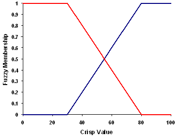
Defines a fuzzy membership function through a linear transformation between the user-specified minimum value, a membership of 0, to the user-defined maximum value, which is assigned a membership of 1.
Debate
The tool that uses the FuzzyLinear object: Fuzzy Membership.
The Linear function is useful when the smaller values linearly increase in membership to the larger values for a positive slope and opposite for a negative slope.
The Linear function does not work with negative numbers.

Sintaxis
FuzzyLinear (minimum, maximum)
| Parámetro | Explicación | Tipo de datos |
minimum | The value that will have a membership of 0. If the minimum value is less than the maximum, the linear function will have a positive slope. If the minimum value is greater than the maximum, the linear function will have a negative slope. (El valor predeterminado es Minimum of the input) | Double |
maximum | The value that will have a membership of 1. If the maximum value is greater than the minimum, the linear function will have a positive slope. If the maximum value is less than the minimum, the linear function will have a negative slope. (El valor predeterminado es Maximum of the input) | Double |
Propiedades
| Propiedad | Explicación | Tipo de datos |
| minimum (Lectura y escritura) | The value that will have a membership of 0. If the minimum value is less than the maximum, the linear function will have a positive slope. If the minimum value is greater than the maximum, the slope will have a negative slope. | Double |
| maximum (Lectura y escritura) | The value that will have a membership of 1. If the maximum value is greater than the minimum, the linear function will have a positive slope. If the maximum value is less than the minimum, the slope will have a negative slope. | Double |
Muestra de código
FuzzyLinear example 1 (Python window)
Demonstrates how to create a FuzzyLinear class and use it in the FuzzyMembership tool within the Python window.
import arcpy
from arcpy.sa import *
from arcpy import env
env.workspace = "c:/sapyexamples/data"
outFzyMember = FuzzyMembership("as_std", FuzzyLinear(12, 16))
outFzyMember.save("c:/sapyexamples/fzyline")
FuzzyLinear example 2 (stand-alone script)
Performs a FuzzyMembership using the FuzzyLinear class.
# Name: FuzzyLinear_Ex_02.py
# Description: Scales input raster data into values ranging from zero to one
#     indicating the strength of a membership in a set.
# Requirements: Spatial Analyst Extension

# Import system modules
import arcpy
from arcpy import env
from arcpy.sa import *

# Set environment settings
env.workspace = "C:/sapyexamples/data"

# Set local variables
inRaster = "as_std"

# Create the FuzzyLinear algorithm object
min = 19
max = 22
myFuzzyAlgorithm = FuzzyLinear(min, max)

# Check out the ArcGIS Spatial Analyst extension license
arcpy.CheckOutExtension("Spatial")

# Execute FuzzyMembership
outFuzzyMember = FuzzyMembership(inRaster, myFuzzyAlgorithm)

# Save the output
outFuzzyMember.save("c:/sapyexamples/fzyline2")