Resumen
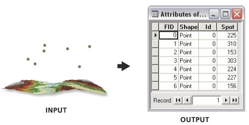
Calculates surface values for each point of a point feature class by interpolating from a raster, TIN, or terrain dataset surface.
Calculated values are added to the input feature class attributes.
Ilustración

Uso
Ensure the input surface and the input feature class have overlapping extents.
Use the Z Factor parameter to convert the output field to the desired units.
Sintaxis
SurfaceSpot(in_surface, in_feature_class, {out_spot_field}, {z_factor}, {method}, {pyramid_level_resolution})| Parámetro | Explicación | Tipo de datos |
in_surface | The input raster, TIN, or Terrain dataset surface to be used for interpolation. | Terrain Layer; TIN Layer; Raster Layer |
in_feature_class | The input point feature class to which the interpolated values will be added. | Feature Layer |
out_spot_field (Opcional) | The name of the attribute field to be added to the input feature class. By default, the field name will be Spot. | String |
z_factor (Opcional) | The factor multiplied by the surface values to convert them to new values added to the input feature class. Used to convert z units to match x,y units. | Double |
method (Opcional) | Algorithm used to calculate surface values. | String |
pyramid_level_resolution (Opcional) | The resolution of the terrain dataset pyramid level to use for geoprocessing. The default is 0, full resolution. | Double |
Salida derivada
| Nombre | Explicación | Tipo de datos |
| output_feature_class | Feature Layer |
Muestra de código
Surface Spot example 1 (Python window)
The following Python Window script demonstrates how to use the Surface Spotfunction in immediate mode.
import arcgisscripting
gp = arcgisscripting.create()

gp.CheckOutExtension("3D")
gp.workspace = "C:/data"
gp.SurfaceSpot_3d("elevation_tin", "points.shp", "SPOT", 3.28)
Entornos
Información sobre licencias
- Basic: Requiere 3D Analyst
- Standard: Requiere 3D Analyst
- Advanced: Requiere 3D Analyst