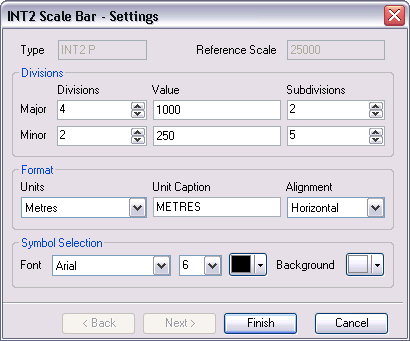
The ArcGIS Maritime supports the creation of INT2 scale bars. The INT2 Scale Bar tool sets the default properties based on the map scale and the INT2 specification for scale bars. You can modify these properties or accept the default settings and click Finish. The scale bar is automatically generated and inserted in the layout.
| Scale Bar Style | Largest Scale | Smallest Scale | Interval (metres) | Minor Subdivision (metres) |
|---|---|---|---|---|
O | – | 1:12500 | 100 | 20 |
P | Smaller than 1:12500 | 1:30000 | 500 | 50 |
Q | Smaller than 1:30000 | 1:50000 | 1000 | 100 |
R | Smaller than 1:50000 | 1:80000 | 1000 | 200 |
Accessing the INT2 Scale Bar wizard
You can access the INT2 Scale Bar tool when you are in the layout view in ArcMap, and when your map scale is set.
- Inicie ArcMap.
- On the Nautical Cartography toolbar, click the INT2 Scale Bar tool.
The INT2 Scale Bar - Settings dialog box appears.

Modifying the format
The default settings are based on the IHO INT2 specification. You can modify them based on your specific requirements, or accept the defaults and click Finish.
- Click the Units drop-down arrow and choose the map units used to create the scale bar.
- Type a value for the Unit Caption to choose a label description of the map units.
- Click the Alignment drop-down arrow and choose whether you want to create the scale bar horizontally or vertically.
- Continue to the next section or click Finish.
Modifying the divisions
The default settings are based on the IHO INT2 specification. You can modify them based on your specific requirements, or accept the defaults and click Finish.
-
Click the Major Divisions up or down arrow to set the major divisions.
These divisions are drawn to the right of zero.
- Type the value (in map units) of each major division in the Major Value text box.
-
Click the Major Subdivisions up or down arrow for the major subdivision.
This is the number of divisions between each major division.
-
Click the Minor Divisions up or down arrow to set the minor divisions.
These divisions are drawn to the left of zero.
- Type the value (in map units) of each minor division in the Minor Value text box.
-
Click the Minor Subdivisions up or down arrow for the minor subdivision.
This is the number of divisions between each minor division.
- Continue to the next section or click Finish.
Modifying the symbols
The default settings are based on the IHO INT2 specification. You can modify them based on your specific requirements, or accept the defaults and click Finish.
- Click the Font drop-down arrow and choose the font that will be used to display the unit caption and the numeric values.
- Click the drop-down arrow and choose the size of the font for the unit caption and value labels.
- Click Color and set the color for all scale bar components.
- Click the Background drop-down arrow to choose a color for the background of the scale bar.
- Haga clic en Finalizar.
The INT2 scale bar is inserted in the layout.