ArcGIS for Desktop

  • Documentation
  • Tarification
  • Support

  • My Profile
  • Aide
  • Sign Out
ArcGIS for Desktop

ArcGIS Online

La plateforme cartographique de votre organisation

ArcGIS for Desktop

Un SIG professionnel complet

ArcGIS for Server

SIG dans votre entreprise

ArcGIS for Developers

Outils de création d'applications de localisation

ArcGIS Solutions

Modèles d'applications et de cartes gratuits pour votre secteur d'activité

ArcGIS Marketplace

Téléchargez des applications et des données pour votre organisation.

  • Documentation
  • Tarification
  • Support
Esri
  • Se connecter
user
  • Mon profil
  • Déconnexion

Help

  • Accueil
  • Commencer
  • Carte
  • Analyser
  • Gérer les données
  • Outils
  • Plus...

Accessing the metadata for selected datasets

Through the Explore Bathymetry tool, you can define filters based on the metadata values associated with the listed bathymetry datasets. You can also update the extended metadata values within the Explore Bathymetry window using the Edit Properties tool.

Remarque :

Any extended metadata fields you update through the Edit Properties dialog box could potentially affect the current bathymetry dataset filter defined in the Explore Bathymetry window.

  1. Start ArcMap.
  2. On the main menu, click Customize > Toolbars > Bathymetry.
  3. Click the Explore Bathymetry button Explore Bathymetry on the Bathymetry toolbar.

    The Explore Bathymetry window appears. The right side of the window lists all datasets associated with the BIS geodatabase.
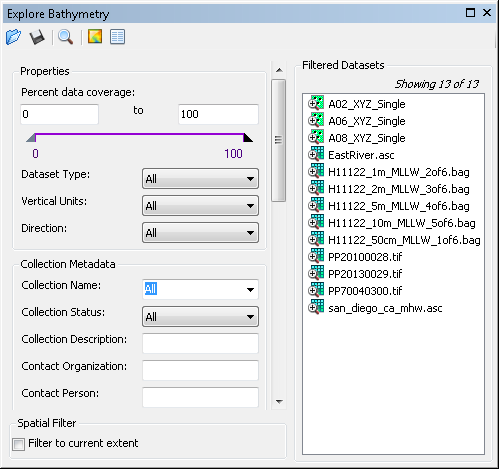
    Explore Bathymetry window
  4. To access the metadata for all datasets currently listed in the Filtered Datasets list, click the Edit Properties button Edit Properties at the top of the Explore Bathymetry window.

    Remarque :

    You can select multiple datasets using the Shift or Ctrl keys. To access and edit metadata for only a particular dataset or group of datasets, right-click a dataset or selection and click Edit Properties or Edit Properties for Selected.

    The Edit Properties dialog box appears.
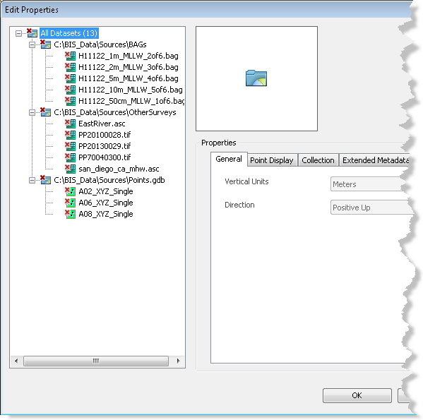
    Edit Properties dialog box
    Remarque :

    The All Datasets parent node is highlighted by default. Any properties or metadata values that are shared by all datasets under this node will be reflected in the tab view. If values differ for the datasets in the dataset tree view, the value for that property or parameter will be shown as blank.

  5. Click one of the datasets in the gridded data tree view to highlight it.

    The previously defined general, point display, collection, extended, and internal metadata values are listed and viewable for the selected dataset.

    Remarque :

    You can also click back to the All Datasets node or a dataset's parent folder to batch edit multiple datasets.

  6. Optionally update the applicable metadata fields on the Extended Metadata tab.

    Remarque :

    General, point display, collection, and internal metadata values are read-only.

  7. Click Apply.

    The metadata updates are applied to the selected dataset.

  8. Optionally choose a different dataset listed in the gridded data tree view.
  9. Repeat steps 6 through 9.
  10. Cliquez sur OK.

Thèmes connexes

  • Bathymetry filters
  • Adding filtered bathymetry from the Explore Bathymetry window
  • Adding filtered bathymetry from the Compose Surface window
Vous avez un commentaire à formuler concernant cette rubrique ?

ArcGIS for Desktop

  • Accueil
  • Documentation
  • Tarification
  • Support

ArcGIS Platform

  • ArcGIS Online
  • ArcGIS for Desktop
  • ArcGIS for Server
  • ArcGIS for Developers
  • ArcGIS Solutions
  • ArcGIS Marketplace

A propos d'Esri

  • A propos de la société
  • Carrières
  • Blog des initiés
  • Conférence des utilisateurs
  • Sommet des développeurs
Esri
© Copyright 2016 Environmental Systems Research Institute, Inc. | Confidentialité | Légal