ArcGIS for Desktop

  • Documentation
  • Tarification
  • Support

  • My Profile
  • Aide
  • Sign Out
ArcGIS for Desktop

ArcGIS Online

La plateforme cartographique de votre organisation

ArcGIS for Desktop

Un SIG professionnel complet

ArcGIS for Server

SIG dans votre entreprise

ArcGIS for Developers

Outils de création d'applications de localisation

ArcGIS Solutions

Modèles d'applications et de cartes gratuits pour votre secteur d'activité

ArcGIS Marketplace

Téléchargez des applications et des données pour votre organisation.

  • Documentation
  • Tarification
  • Support
Esri
  • Se connecter
user
  • Mon profil
  • Déconnexion

Help

  • Accueil
  • Commencer
  • Carte
  • Analyser
  • Gérer les données
  • Outils
  • Plus...

Modifying the BIS system settings

You can modify your active Bathymetry Information System (BIS) connection settings using the Manage BIS Settings tool. This tool allows you to change the BIS local alias and modify implementation details stored in the BisDetails table within the BIS geodatabase.

  1. Start ArcMap.
  2. On the main menu, click Customize > Toolbars > Bathymetry.
  3. Click the Manage BIS Settings button Manage BIS Settings on the Bathymetry toolbar.

    The Manage BIS Settings dialog box appears. The settings for your active BIS geodatabases are shown in the dialog box. The location of the BIS database and coordinate system were set when the BIS geodatabase was created and are read-only and cannot be changed.
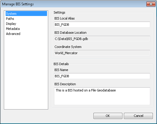
    Manage BIS Settings dialog box
  4. Ensure that the System pane is active.
  5. In the Settings section, type a new alias name for the active BIS geodatabase in the BIS Local Alias text box.
  6. If you are an administrator and need a new name for the BIS geodatabase, type a new name in the BIS Name text box in the BIS Details section.

    This updates the name of the BIS internally but does not change the name of the database itself or modify the database connection. The BIS Name value is stored within the BIS geodatabase and is defined by the BIS administrator; if you are not an administrator, it is highly recommended that you do not alter it.

    Astuce:

    If you need to uniquely identify the BIS workspace on your local setup, use the BIS Local Alias value to do so.

  7. Type a new description in the BIS Description text box.
  8. Cliquez sur OK.

Your updated BIS geodatabase settings are saved.

Thèmes connexes

  • Modifying the color ramp
Vous avez un commentaire à formuler concernant cette rubrique ?

ArcGIS for Desktop

  • Accueil
  • Documentation
  • Tarification
  • Support

ArcGIS Platform

  • ArcGIS Online
  • ArcGIS for Desktop
  • ArcGIS for Server
  • ArcGIS for Developers
  • ArcGIS Solutions
  • ArcGIS Marketplace

A propos d'Esri

  • A propos de la société
  • Carrières
  • Blog des initiés
  • Conférence des utilisateurs
  • Sommet des développeurs
Esri
© Copyright 2016 Environmental Systems Research Institute, Inc. | Confidentialité | Légal