ArcGIS Desktop

  • Documentation
  • Support

  • My Profile
  • Aide
  • Sign Out
ArcGIS Desktop

ArcGIS Online

La plateforme cartographique de votre organisation

ArcGIS Desktop

Un SIG professionnel complet

ArcGIS Enterprise

SIG dans votre entreprise

ArcGIS for Developers

Outils de création d'applications de localisation

ArcGIS Solutions

Modèles d'applications et de cartes gratuits pour votre secteur d'activité

ArcGIS Marketplace

Téléchargez des applications et des données pour votre organisation.

  • Documentation
  • Support
Esri
  • Se connecter
user
  • Mon profil
  • Déconnexion

ArcMap

  • Accueil
  • Commencer
  • Carte
  • Analyser
  • Gérer les données
  • Outils
  • Extensions

Accounting for anisotropy using directional semivariogram and covariance functions

Disponible avec une licence Geostatistical Analyst.

Because you are working in two-dimensional space, you might expect that the semivariogram and covariance functions change not only with distance but with direction as well. This is called anisotropy.

Learn more about semivariogram and covariance functions

Consider two points, si and sj, and the vector that separates them, which is denoted as si - sj. This vector will have a distance on the x-axis as well as the y-axis. Alternatively, you can think of the vector as having a distance and an angle in polar coordinates. Here anisotropy is described for the semivariogram; the ideas are similar for covariance functions.

The isotropic model is the same in all directions, whereas the anisotropic model reaches the sill more rapidly in some directions than others. The length of the longer axis to reach the sill is called the major range, the length of the shorter axis to reach the sill is called the minor range, and you also have the angle of rotation of the line that forms the major range. In Geostatistical Analyst, an outline of the range is given in blue, over the empirical semivariogram surface.
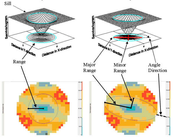
Anisotropy diagram

ArcGIS Desktop

  • Accueil
  • Documentation
  • Support

ArcGIS Platform

  • ArcGIS Online
  • ArcGIS Desktop
  • ArcGIS Enterprise
  • ArcGIS for Developers
  • ArcGIS Solutions
  • ArcGIS Marketplace

A propos d'Esri

  • A propos de la société
  • Carrières
  • Blog des initiés
  • Conférence des utilisateurs
  • Sommet des développeurs
Esri
Donnez-nous votre avis.
© Copyright 2016 Environmental Systems Research Institute, Inc. | Confidentialité | Légal