Disponible avec une licence Production Mapping.
Résumé
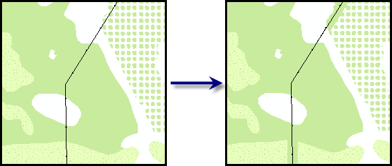
Determines which polygon features are directly below a line feature. If the type of feature is valid, which is determined by the subtype or feature class, the tool expands the feature to ensure that it meets minimum distance requirements. If it does not meet the minimum distance requirement, the part of the polygon feature under the line is removed and replaced with an appropriate type of feature.
Illustration

Utilisation
Un avertissement s'affiche si les entités en entrée ne sont pas dans un système de coordonnées projetées. Cet outil s'appuie sur des unités de distance linéaire, qui créent des résultats inattendus dans un système de coordonnées non projetées. Nous vous conseillons vivement d'exécuter cet outil sur des données dans un système de coordonnées projetées pour obtenir des résultats fiables. Une erreur s'affiche et l'outil ne fonctionne pas si le système de coordonnées manque ou s'il est inconnu.
This tool is mainly useful for enhancing the cartographic appearance of data at different scales. For example, suppose you have powerlines overlaying a vegetation area. If the forest symbol is complex and is composed of several small symbols that represent trees, the points representing the power poles may be difficult to see. To avoid this, you can simplify the symbology by replacing the forest symbol with a more general, solid green symbol so it is still understood that vegetation exists there.
This tool works with simple geometries such as squares, rectangles, and circles. It does not work with more complex shapes, such as ellipses.
Only polygons that are coincident with line features are affected by this tool.
The buffer distance can be used to ensure that the line can be clearly seen on the map when there are lines and polygons in the same area.
When replacement features are defined, you can also indicate which features will be created using the Replace Value (Replace_Value) parameter. For example, if the forest symbol contains a stipple that obscures line features that overlay it, you can replace it with the shrub subtype or the grass feature class, which are represented by solid green symbols.
If this tool is run in an edit session in ArcMap, you can stop the edit session without saving changes to restore features that have been deleted.
Syntaxe
arcpy.production.ModifyUnderlyingPolygon(Input_Line_Features, Buffer_Distance, Input_Features_Under_Line, {Keep_features_underneath_lines}, {Replace_Features}, {Replace_Value})| Paramètre | Explication | Type de données |
Input_Line_Features | Lines that serve as a reference point for the polygons under them. The tool searches behind these lines to identify polygons that need to be modified or deleted. | Feature Layer |
Buffer_Distance | The minimum distance the edge of the valid polygon features can be from the line. If the polygon is closer than the minimum distance, parts will be deleted until it is within the buffer distance. If the polygon is farther away than the minimum distance, it is expanded until it meets the buffer distance. | Linear unit |
Input_Features_Under_Line | The polygons that will be checked to determine whether they have features that lie under the lines. | Feature Layer |
Keep_features_underneath_lines (Facultatif) | Specifies whether the types of features directly under the lines, based on either the subtype or feature class, are allowed to be under the line or will be replaced.
| Boolean |
Replace_Features (Facultatif) | The polygon features that will fill the buffer distance under the line if the features in Input_Features_Under_Line are not valid. | Feature Class |
Replace_Value (Facultatif) | The subtype code or description to be assigned to the features in the Replace_Features feature class. | String |
Exemple de code
ModifyUnderlyingPolygon (stand-alone script)
The following stand-alone script sample demonstrates how to use the ModifyUnderlyingPolygon function.
# Name: ModifyUnderlyingPolygon_Example.py
# Description: Executes Modify Underlying Polygon against LocalGovernment
# sample data
# Author: Esri
# Date: February 2014

# Import arcpy module
import arcpy

# Check out Production Mapping license
arcpy.CheckOutExtension("Foundation")

# Set environment
arcpy.env.workspace="c:/data/LocalGovernment.gdb"

# Define variables
inFeatures="ReferenceData/RoadCenterline"
inFeatureLyr="RoadLayer"
inPolys="ReferenceData/FacilitySite"
inPolysLyr="FaciltyLayer"
bufferIncrease="100 Feet"
replace="REPLACE_FEATURES"

# create feature layers for ModifyUnderlyingPolygon
arcpy.MakeFeatureLayer_management(inFeatures,inFeatureLyr)
arcpy.MakeFeatureLayer_management(inPolys,inPolysLyr)

# execute ModifyUnderlyingPolygon
arcpy.ModifyUnderlyingPolygon_production(inFeatureLyr,bufferIncrease,inPolysLyr,replace)
Environnements
Informations de licence
- Basic: Non
- Standard: Requiert Production Mapping
- Advanced: Requiert Production Mapping