ArcGIS Desktop

  • ArcGIS Pro
  • ArcMap

  • My Profile
  • Aide
  • Sign Out
ArcGIS Desktop

ArcGIS Online

La plateforme cartographique de votre organisation

ArcGIS Desktop

Un SIG professionnel complet

ArcGIS Enterprise

SIG dans votre entreprise

ArcGIS Developers

Outils de création d'applications de localisation

ArcGIS Solutions

Modèles d'applications et de cartes gratuits pour votre secteur d'activité

ArcGIS Marketplace

Téléchargez des applications et des données pour votre organisation.

  • Documentation
  • Support
Esri
  • Se connecter
user
  • Mon profil
  • Déconnexion

ArcMap

  • Accueil
  • Commencer
  • Carte
  • Analyser
  • Gérer les données
  • Outils
  • Extensions

Modifying the color ramp

The Manage BIS Settings tool allows you to set a default local color ramp for data visualized in the Explore Bathymetry and Compose Surface windows. For bathymetry data, a color ramp applies a range of colors to the range of depth values associated with a surface model. ArcGIS Bathymetry provides you with standard color ramps used within the bathymetric community.

Remarque :

Changes made to the default local color ramp will only be visible on the local machine that the changes were made on. This setting does not affect other users or machines connected to the BIS geodatabase.

  1. Start ArcMap.
  2. Click Customize > Toolbars > Bathymetry on the main menu to activate the Bathymetry toolbar if necessary.
  3. Click the Manage BIS Settings button Manage BIS Settings on the Bathymetry toolbar.

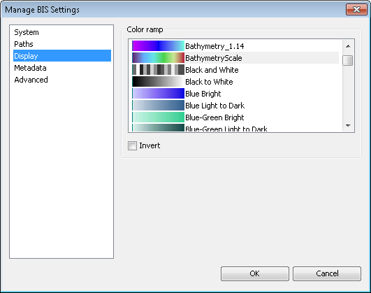
    The Manage BIS Settings dialog box appears. The settings for your active BIS geodatabase are shown in this dialog box.

    Manage BIS Settings dialog box
  4. Click the Display pane.
    Manage BIS Settings dialog box Display pane
  5. In the Color Ramp section, choose the color ramp that you want to use to visualize data in the Explore Bathymetry and Compose Surface windows.

    Modifying the color ramp will not automatically update the thumbnail previews of the data or the color ramp in ArcMap.

    Astuce :

    You can quickly jump to any of the available color ramps by selecting a color ramp and typing the first letter of the color ramp name. For example, to find a specific blue color ramp, click a color ramp and type the letter B multiple times to scroll through the list of blue color ramps.

  6. Optionally, check the Invert check box to insert the color ramp.

    Any mosaic dataset previews created after this check box is checked will be generated using the inverted color ramp.

  7. Cliquez sur OK.

Rubriques connexes

  • Modifying the BIS system settings

ArcGIS Desktop

  • Accueil
  • Documentation
  • Support

ArcGIS

  • ArcGIS Online
  • ArcGIS Desktop
  • ArcGIS Enterprise
  • ArcGIS
  • ArcGIS Developer
  • ArcGIS Solutions
  • ArcGIS Marketplace

A propos d'Esri

  • A propos de la société
  • Carrières
  • Blog d’Esri
  • Conférence des utilisateurs
  • Sommet des développeurs
Esri
Donnez-nous votre avis.
Copyright © 2021 Esri. | Confidentialité | Légal