ArcGIS Desktop

  • ArcGIS Pro
  • ArcMap

  • My Profile
  • Aide
  • Sign Out
ArcGIS Desktop

ArcGIS Online

La plateforme cartographique de votre organisation

ArcGIS Desktop

Un SIG professionnel complet

ArcGIS Enterprise

SIG dans votre entreprise

ArcGIS Developers

Outils de création d'applications de localisation

ArcGIS Solutions

Modèles d'applications et de cartes gratuits pour votre secteur d'activité

ArcGIS Marketplace

Téléchargez des applications et des données pour votre organisation.

  • Documentation
  • Support
Esri
  • Se connecter
user
  • Mon profil
  • Déconnexion

ArcMap

  • Accueil
  • Commencer
  • Carte
  • Analyser
  • Gérer les données
  • Outils
  • Extensions

Choosing a new spatial reference for the solution

Disponible avec une licence Production Mapping.

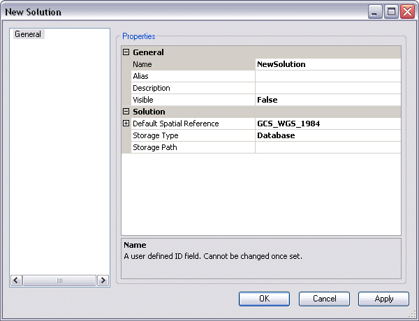
The spatial reference that will be used when the product class is created needs to be defined at the solution level of the product library. The areas of interest will be stored using this spatial reference. The steps below are to define a new spatial reference, but you can also define an existing spatial reference for your solution. The new spatial reference can be defined in the New Solution or the Solution Properties dialog box.

  1. Start ArcMap.
  2. If you do not have the New Solution dialog box open, right-click an existing solution from the Product Library tree view and click Properties to open the Solution Properties dialog box.
  3. Click the plus sign (+) next to Default Spatial Reference.
    Astuce :

    You can do this in the New Solution or the Solution Properties dialog box, depending on which one you have open.

    Default Spatial Reference properties on the New Solution dialog box

  4. Click the cell next to Use Existing.
  5. Click the drop-down arrow that appears and choose False.
  6. Click the cell next to Base Spatial Reference and click the ellipsis (...) that appears.

    The Spatial Reference Properties dialog box appears.

  7. Click Select.

    The Browse for Coordinate System dialog box appears.

  8. Navigate to the coordinate system you want to use for your area of interest.
  9. Click Add.

    The Spatial Reference Properties dialog box appears.

  10. Click OK.

    The New Solution or the Solution Properties dialog box appears, depending on which one you have open.

  11. Cliquez sur OK.

ArcGIS Desktop

  • Accueil
  • Documentation
  • Support

ArcGIS

  • ArcGIS Online
  • ArcGIS Desktop
  • ArcGIS Enterprise
  • ArcGIS
  • ArcGIS Developer
  • ArcGIS Solutions
  • ArcGIS Marketplace

A propos d'Esri

  • A propos de la société
  • Carrières
  • Blog d’Esri
  • Conférence des utilisateurs
  • Sommet des développeurs
Esri
Donnez-nous votre avis.
Copyright © 2021 Esri. | Confidentialité | Légal