ArcGIS Desktop

  • ArcGIS Pro
  • ArcMap

  • My Profile
  • Aide
  • Sign Out
ArcGIS Desktop

ArcGIS Online

La plateforme cartographique de votre organisation

ArcGIS Desktop

Un SIG professionnel complet

ArcGIS Enterprise

SIG dans votre entreprise

ArcGIS Developers

Outils de création d'applications de localisation

ArcGIS Solutions

Modèles d'applications et de cartes gratuits pour votre secteur d'activité

ArcGIS Marketplace

Téléchargez des applications et des données pour votre organisation.

  • Documentation
  • Support
Esri
  • Se connecter
user
  • Mon profil
  • Déconnexion

ArcMap

  • Accueil
  • Commencer
  • Carte
  • Analyser
  • Gérer les données
  • Outils
  • Extensions

Ensuring DEM consistency

Disponible avec une licence Production Mapping.

The Set Consistent DEMs Symbology tool allows you to set the digital elevation model (DEM) so the DTEDs in your map appear to have the same heights.

  1. Start ArcMap.
  2. Load the DEM files you want to use to create contours in ArcMap.
  3. On the main menu, click Customize > Toolbars > Production Contouring.
  4. Click the Set Consistent DEMs Symbology button Set Consistent DEMs Symbology on the Production Contouring toolbar.

    The Set Consistent DEM Symbology dialog box appears.
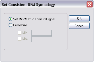
    Set Consistent DEM Symbology dialog box
  5. Choose the minimum/maximum height option you want to use for your raster layers.
    • Set Min/Max to Lowest/Highest—The lowest and highest values of the DEM layer are automatically found, and the visual representation is set accordingly so the layers' heights are all the same.
    • Customize—You define the minimum and maximum values for the layer.
      Remarque :
      If you define one and not the other, the value is automatically set.
  6. If you chose Customize in the previous step, do one or both of the following:

    To define the minimum value

    Check the Min check box and type a value in the Min text box for the minimum height values for the layer.

    To define the maximum value

    Check the Max check box and type a value in the Max text box for the maximum height of the layer.

  7. Click OK.

Rubriques connexes

  • Merging DEMs
  • Filtering DEMs

ArcGIS Desktop

  • Accueil
  • Documentation
  • Support

ArcGIS

  • ArcGIS Online
  • ArcGIS Desktop
  • ArcGIS Enterprise
  • ArcGIS
  • ArcGIS Developer
  • ArcGIS Solutions
  • ArcGIS Marketplace

A propos d'Esri

  • A propos de la société
  • Carrières
  • Blog d’Esri
  • Conférence des utilisateurs
  • Sommet des développeurs
Esri
Donnez-nous votre avis.
Copyright © 2021 Esri. | Confidentialité | Légal