サマリ
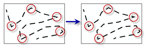
ライン方向の変化分だけ生じた角度が、指定した最大角度以下であるラインまたはポリゴンのアウトライン上の頂点にリプレゼンテーション コントロール ポイントを配置します。
図

使用法
入力フィーチャは、リプレゼンテーションでシンボル表示されたライン レイヤーまたはポリゴン レイヤーにする必要があります。
頂点の変更は、フィーチャ リプレゼンテーションのジオメトリ オーバーライドとして保存されます。
構文
SetRepresentationControlPointByAngle_cartography (in_features, maximum_angle)
| パラメータ | 説明 | データ タイプ |
in_features | ラインまたはポリゴンのリプレゼンテーションが含まれる入力フィーチャ レイヤー。 | Layer |
maximum_angle | ラインまたはポリゴンのアウトライン上の頂点をリプレゼンテーション コントロール ポイントとして設定するかどうかの決定に使用する角度。角度の値は 0 よりも大きく、180 度 (10 進) 未満にする必要があります。 | Double |
コードのサンプル
SetRepresentationControlPointByAngle (角度でリプレゼンテーション コントロール ポイントを設定) ツールの例 (Python ウィンドウ)
次の Python ウィンドウ スクリプトは、イミディエイト モードで SetRepresentationControlPointByAngle (角度でリプレゼンテーション コントロール ポイントを設定) ツールを使用する方法を示しています。
import arcpy
from arcpy import env
env.workspace = "C:\data"

arcpy.SetRepresentationControlPointByAngle_cartography("trails.lyr", "135")
SetRepresentationControlPointByAngle (角度でリプレゼンテーション コントロール ポイントを設定) ツールの例 (スタンドアロン Python スクリプト)
次のスタンドアロン スクリプトは、SetRepresentationControlPointByAngle (角度でリプレゼンテーション コントロール ポイントを設定) ツールを使用する例を示しています。
# Name: SetRepresentationControlPointByAngle_standalone_script.py
# Description: adds representation control points at locations where a feature has a sharp angle in its geometry
# Author: ESRI

# Import system modules
import arcpy
from arcpy import env

# Set environment settings
env.workspace = "C:/data"

# Set local variables
in_representations = "trails.lyr"
minimum_angle_deviation = "135"

# Execute Set Representation Control Point At Intersect
arcpy.SetRepresentationControlPointAtIntersect_cartography(in_representations, minimum_angle_deviation)
環境
このツールはジオプロセシング環境を使用していません
ライセンス情報
- ArcGIS for Desktop Basic: ×
- ArcGIS for Desktop Standard: ×
- ArcGIS for Desktop Advanced: ○