Production Mapping ライセンスで利用できます。
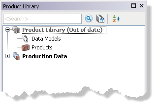
The Upgrade Product Library command updates all the components necessary for your geodatabase to perform as a product library. This command is activated if there was an upgrade on the schema from one version of a release to another for Esri Mapping and Charting solutions. It shows an Out of date message and is disabled.
If you are upgrading an エンタープライズ ジオデータベース, you can only perform the upgrade if you connect as the schema owner for the workspace.
- Start ArcMap.
- If necessary, open the Product Library window by clicking Customize > Production > Product Library on the main menu.
A tree view of the product library appears.

- Right-click the Product Library icon and click Upgrade Product Library.
The Upgrade Product Library Workspace dialog box appears.
- Click the drop-down arrow in the Select Configuration Keyword area and choose an option.
Options may vary based on whether the database is a personal, file, or エンタープライズ ジオデータベース. For an エンタープライズ ジオデータベース, you can choose DEFAULTS unless you have configured a different geodatabase configuration keyword.
- DEFAULTS—Stores data up to 1 TB in size; text is stored in UTF8 format.
- TEXT_UTF16—Stores data up to 1 TB in size; text is stored in UTF16 format.
- MAX_FILE_SIZE_4GB—Limits data size to 4 GB; text is stored in UTF8 format.
- MAX_FILE_SIZE_256TB—Stores data up to 256 TB in size; text is stored in UTF8 format.
- GEOMETRY_OUTOFLINE—Stores data up to 1 TB in size; text is stored in UTF8 format; stores the geometry attribute in a file separate from the nonspatial attributes.
- BLOB_OUTOFLINE—Stores data up to 1 TB in size; text is stored in UTF8 format; stores BLOB attributes in a file separate from the rest of the attributes.
- GEOMETRY_AND_BLOB_OUTOFLINE—Stores data up to 1 TB in size; text is stored in UTF8 format; stores both geometry and BLOB attributes in files separate from the rest of the attributes.
- Click OK.
The Upgrading Product Library Workspace dialog box appears with the progress.
- Click OK when the process completes.
If the product library supports at least one of the Esri Mapping and Charting solutions, it upgrades the tables that are part of the extension listed in the ToolTip. The product library will also display (Missing Extensions) next to Product Library if the product library supports an Esri Mapping and Charting solution that is not installed.