ArcGIS Desktop

  • ArcGIS Pro
  • ArcMap

  • My Profile
  • ヘルプ
  • Sign Out
ArcGIS Desktop

ArcGIS Online

組織のマッピング プラットフォーム

ArcGIS Desktop

完全なプロ仕様の GIS

ArcGIS Enterprise

エンタープライズ GIS

ArcGIS Developers

位置情報利用アプリの開発ツール

ArcGIS Solutions

各種業界向けの無料のテンプレート マップおよびテンプレート アプリケーション

ArcGIS Marketplace

組織で使えるアプリとデータを取得

  • ドキュメント
  • サポート
Esri
  • サイン イン
user
  • マイ プロフィール
  • サイン アウト

ArcMap

  • Home
  • Get Started
  • Map
  • Analyze
  • Manage Data
  • Tools
  • Extensions

Elevation data on routes

  • Adding z-values to centerlines using editing tools
  • Adding z-values to centerlines using a raster dataset

Esri Roads and Highways supports 3D elevation data on route and centerline vertices. The centerline should be enabled to store z-values for each vertex. These z-values are used to store elevation data and can be used to calculate 3D measure values when calibrating routes in the network depending on the calibration method you choose. Since centerlines make up the routes in the network feature class, the network is also enabled to store z-values.

注意:

Redlines can also be z-enabled if you choose to use a redline as your source geometry.

To populate the z-values on a centerline being used to create a route or edited during cartographic realignment, either add the values manually using the ArcMap editing tools or configure a raster dataset, such as a Digital Terrain Model (DTM) or Digital Elevation Model (DEM), with your LRS to automatically populate the values.

Adding z-values to centerlines using editing tools

When digitizing a new or editing an existing centerline feature, z-values can be added or edited by opening the sketch properties for the feature and populating the z-values for each vertex on the feature.
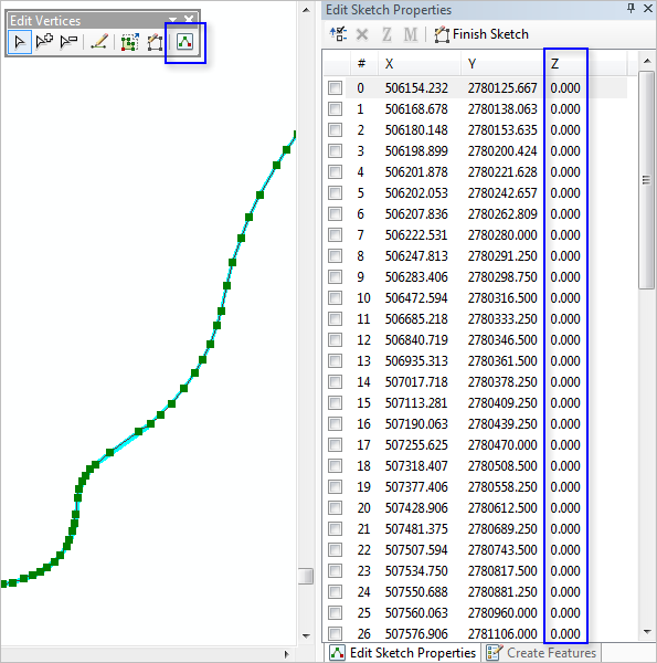
Editing z-values in sketch properties

Adding z-values to centerlines using a raster dataset

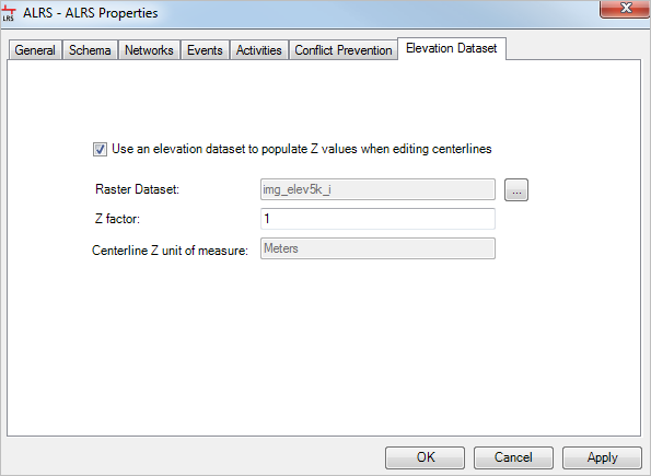
A raster dataset, such as a DTM or DEM, can be configured with your LRS to populate the z-values on newly digitized or edited centerlines in Roads and Highways.

Learn more about configuring a raster dataset in your LRS
注意:

The 3D Analyst extension is required to use this functionality.

注意:

While raster datasets such as DEM are supported, they may not reflect bridges, overpasses, and other raised roadways. Consider using a DTM to account for locations where a roadway varies from the elevation of the ground below it.

Raster dataset configured as elevation dataset in ALRS properties

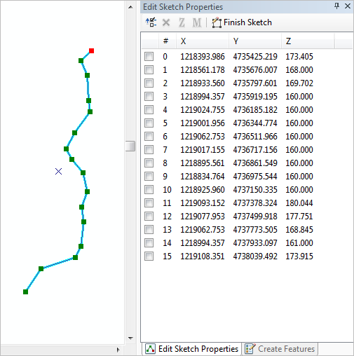
When a raster dataset is configured with your LRS, any digitized or edited centerline has z-values automatically applied based on the value of the raster dataset at that location.
注意:

These z-values are applied only to centerlines digitized or edified in an edit session. Centerlines loaded using the Load Routes tool do not have z-values applied from the raster dataset.

Centerline digitized with raster dataset configured with the LRS

In the example above, a newly digitized centerline with a raster dataset is configured with the LRS. The z-values are automatically applied based on the raster dataset.

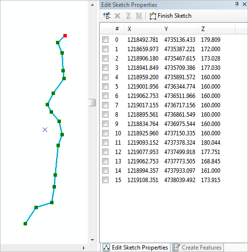
In the following example, the same centerline that has been edited. The location of the first four vertices has changed and the z-values were automatically updated based on the raster dataset.
ヒント:

The z-values populated from the raster dataset can be overwritten simply by changing the value for each vertex.

Centerline edited with z-values automatically updated

ArcGIS Desktop

  • ホーム
  • ドキュメント
  • サポート

ArcGIS

  • ArcGIS Online
  • ArcGIS Desktop
  • ArcGIS Enterprise
  • ArcGIS Developers
  • ArcGIS Solutions
  • ArcGIS Marketplace

Esri について

  • 会社概要
  • 採用情報
  • Esri ブログ
  • ユーザ カンファレンス
  • デベロッパ サミット
Esri
ご意見・ご感想をお寄せください。
Copyright © 2021 Esri. | プライバシー | リーガル