Spatial Analyst のライセンスで利用可能。
概要
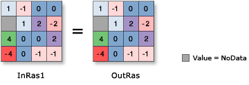
Multiplies each cell value of the input raster on a cell-by-cell basis by 1.
図

ディスカッション
ラスター入力で演算子を使用すると、結果はラスターになります。ただし、すべての入力値が数字の場合、結果は数字になります。
複数の演算子が式に使用されている場合、それらは必ずしも左から右へという順に実行されるわけではありません。優先順位値が最も高い演算子が最初に実行されます。演算子の優先順位に関する詳細については、「演算子の優先順位のテーブル」をご参照ください。実行順序の制御には、括弧が使用できます。
If the input is integer, the output will contain integer values; if the input is floating point, the output will contain floating-point values.
構文
+ in_raster_or_constant
| オペランド | 説明 | データ タイプ |
in_raster_or_constant | The input raster to apply the Unary Plus operator (multiply by 1). | Raster Layer | Constant |
戻り値
| 名前 | 説明 | データ タイプ |
| out_raster | 出力ラスター オブジェクト。 The cell values are the input values multiplied by 1. | Raster |
コードのサンプル
Unary + (Unary Plus) example 1 (Python window)
This sample applies the Unary Plus operator to the input raster.
import arcpy
from arcpy import env
from arcpy.sa import *
env.workspace = "C:/sapyexamples/data"
outUnaryPlus = + Raster("degs")
outUnaryPlus.save("C:/sapyexamples/output/outdeg")
Unary + (Unary Plus) example 2 (stand-alone script)
This sample applies the Unary Plus operator to the input raster.
# Name: Op_UnaryPlus_Ex_02.py
# Description: Returns the cell valuesof the input raster on a cell-by-cell
#    basis.
# Requirements: Spatial Analyst Extension

# Import system modules
import arcpy
from arcpy import env
from arcpy.sa import *

# Set environment settings
env.workspace = "C:/sapyexamples/data"

# Set local variables
inRaster = Raster("degs")

# Check out the ArcGIS Spatial Analyst extension license
arcpy.CheckOutExtension("Spatial")

# Execute Negate
outUnaryPlus = +(inRaster)

# Save the output
outUnaryPlus.save("C:/sapyexamples/output/outunplus")