ArcGIS Desktop

  • ArcGIS Pro
  • ArcMap

  • My Profile
  • ヘルプ
  • Sign Out
ArcGIS Desktop

ArcGIS Online

組織のマッピング プラットフォーム

ArcGIS Desktop

完全なプロ仕様の GIS

ArcGIS Enterprise

エンタープライズ GIS

ArcGIS Developers

位置情報利用アプリの開発ツール

ArcGIS Solutions

各種業界向けの無料のテンプレート マップおよびテンプレート アプリケーション

ArcGIS Marketplace

組織で使えるアプリとデータを取得

  • ドキュメント
  • サポート
Esri
  • サイン イン
user
  • マイ プロフィール
  • サイン アウト

ArcMap

  • ホーム
  • はじめに
  • マップ
  • 解析
  • データ管理
  • ツール
  • エクステンション

Creating airspace lines

The Create Airspace Lines tool generates line data from airspace features. You use this data to generate symbology and labels for both sides of the line features.

  1. Start ArcMap.
  2. Ensure that the correct product library and production database are set.
  3. On the main menu, click Customize > Toolbars > Aviation Data Management.
  4. Click the Create Airspace Lines button Create Airspace Lines on the Aviation Data Management toolbar.

    The Create Airspace Lines dialog box appears.

  5. In the Instance(s) to Process list, expand each node in the tree view until you find the instance against which the tool will run.
  6. Check the check box next to the instance name.
  7. Click the Preference drop-down arrow and choose a preference name.
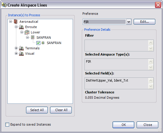
    The Create Airspace Lines dialog box

  8. To modify the airspace line preference, click Edit.
  9. Click OK to run the create airspace lines process.

    The Create Airspace Lines Results dialog box appears.

    メモ:

    Click View Log on the Create Airspace Lines Results dialog box to display additional information about the Create Airspace Lines process.

  10. [閉じる] をクリックします。

関連トピック

  • Creating airspace lines preferences
  • Create airspace lines
  • Creating airspace area preferences

ArcGIS Desktop

  • ホーム
  • ドキュメント
  • サポート

ArcGIS

  • ArcGIS Online
  • ArcGIS Desktop
  • ArcGIS Enterprise
  • ArcGIS
  • ArcGIS Developer
  • ArcGIS Solutions
  • ArcGIS Marketplace

Esri について

  • 会社概要
  • 採用情報
  • Esri ブログ
  • ユーザ カンファレンス
  • デベロッパ サミット
Esri
ご意見・ご感想をお寄せください。
Copyright © 2022 Esri. | プライバシー | リーガル